Great Lakes Observing System
NOAA-certified Great Lakes data supports regional health, safety, and the national economy.

The Great Lakes Need a Great Observing System
The Great Lakes are a vital shipping channel for the U.S., annually carrying billions of dollars of cargo to and from the Atlantic. They also contain 20 percent of the world's freshwater, have 10,000 miles of coast, and heavily influence regional climate. The Great Lakes Observing System plays a key role in knowing what's happening and forecasting what's to come in this ecologically sensitive and economically important region. Shown here: the Straits of Mackinac, Lake Huron, Michigan.
The Great Lakes Observing System (GLOS) is unique in the U.S. Integrated Ocean Observing System (IOOS®) as the only regional association based around freshwater.

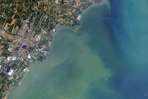
A harmful algal bloom deprived Toledo, Ohio, of safe water for two days in 2014. The Great Lakes Observing System helped communities forecast and respond to the crisis.
The Great Lakes: Vital Waterways
The Great Lakes are a vital shipping channel for the U.S., annually carrying billions of dollars of cargo to and from the Atlantic. They also contain 20 percent of the world's freshwater, have 10,000 miles of coast, and—much like the ocean—the waters of the Great Lakes heavily influence the climate in the region. Knowing what's happening and forecasting what's to come in Lakes Superior, Michigan, Huron, Erie, and Ontario keep us safer, healthier, and economically sound.
The Great Lakes also supply water to 40 million people—both for drinking and for industrial and agricultural purposes—not to mention being home to 250 species of fish. This is why it's critical to keep an eye on water quality in the region. The Great Lakes Observing System works with cities and communities to put in place buoys, water level stations, and other systems that not only monitor water quality, but also help communities forecast and respond to natural disasters, like the harmful algal bloom that deprived Toledo, Ohio, of safe water for two days in 2014. Following the crisis, GLOS developed the HABs Data Portal, a tool that gives users insight into the potential for other dangerous HAB outbreaks..
A Portal into the Great Lakes
The Great Lakes Observing System gathers data from local, state, federal, and private groups, ties it all together, and makes it easy to access via the GLOS data portal. The portal allows users to customize and save their views. A recreational boater, for example, for example, can pull up presets that might be different from a beach manager's in the same community. Whatever one's needs are for Great Lakes observing data, the GLOS network ensures that all data are consistent, are of high quality, and are compatible for all users.
Did you know?
In June 2016, NOAA certified the Great Lakes Observing System as a Regional Information Coordinating Entity—only the second organization to achieve this. The certification signifies a high quality of observing data and operational practices. In simple terms, it means that NOAA and IOOS stand behind GLOS's observing data, and that all users can rely on GLOS for data that meet the reliable, compatible standards being implemented across the IOOS network.
