A Unique Approach to Habitat Conservation in Culebra, Puerto Rico
A Special Place
The picturesque hillsides and vibrant blue waters of northeast Puerto Rico and nearby Culebra Island are home to marine and terrestrial ecosystems that make it a truly special place.
This corner of Puerto Rico is NOAA's only Habitat Blueprint Focus Area in the Caribbean. NOAA's Habitat Blueprint is a national framework to improve habitat for fisheries, marine life, and coastal communities.
Among the most pressing environmental issues here are the impacts from soil erosion and nonpoint source pollution on the coral reefs and other marine habitats that lie just offshore from the rugged hillsides.
With a Dirty Issue
Powerful downpours claw at Culebra's steep slopes and clay soils. These characteristics, combined with coastal development and high recreational use, set the stage for soil erosion on a grand scale.
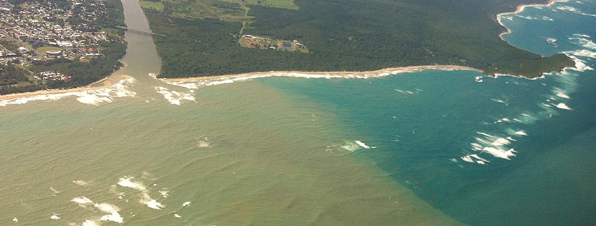
Storm water runoff and pollution can quickly make their way into rivers and out to nearshore marine environments after a rainstorm. This aerial photo of a sediment plume stretching for miles off the northeast coast of Puerto Rico shows just how extensive the problem is for the region.
Additionally, loss of vegetation means that soil and chemicals flow downhill into sensitive marine areas. An influx of sediment can smother corals and seagrass, while chemical pollutants are known to hamper coral growth and disrupt ecosystem function.
Teams are implementing a ridge-to-reef watershed management plan on Culebra Island that emphasizes tackling coastal issues to improve marine ecosystems. They are now seeing the impacts of their work at one of the first project sites, Playa Tamarindo.
Playa Tamarindo—A Watershed Management Success Story
Playa Tamarindo is a scenic beach at the base of a hill on western Culebra Island. It's a favorite spot of locals and tourists alike.
In addition to beachgoers, the area welcomes feeding sea turtles and manatees. It also supports coral nurseries where researchers grow young corals to restore damaged reef areas.
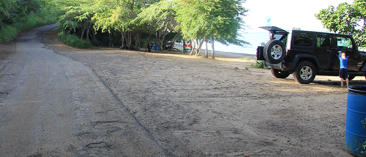
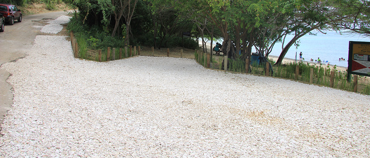
In 2013, experts began implementing several watershed management practices to address runoff caused by surrounding unpaved roads.
Playa Tamarindo before and after watershed management practices were put in to place. Teams employed green infrastructure techniques—like re-vegetating bare soil and installing a gravel parking lot—that work together to reduce stormwater runoff and capture sediment before it reaches the sea.
A Green Infrastructure Approach
Reducing and slowing stormwater runoff is a priority. With the help of Ridge to Reefs and Protectores de Cuencas (Protectors of Basins), two nonprofit partners, experts went to work strategically placing rocks and gravel to slow water flow and direct runoff to vegetated areas where it's naturally filtered before reaching the sea.
Driving cars on the beach was another issue. A specially designed gravel parking lot replaced once bare soil adjacent to the beach. Now the parking lot is composed of a multi-layer system of gravel with plants along the perimeter to further filter stormwater runoff.
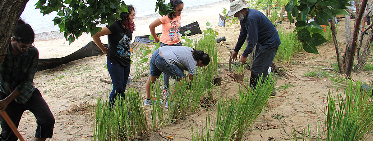
The beachfront was also re-vegetated to stabilize the soil—adding yet another layer of filtration—and a boardwalk was installed to concentrate the flow of foot traffic and protect the plants.
Scientists are using a digital tool called OpenNSPECT from NOAA's Office for Coastal Management to determine the impact of their work and adapt their efforts as necessary. Initial studies show that overall sediment loads to Playa Tamarindo's marine habitats are down.
Community Partnership
The watershed restoration work at Playa Tamarindo is one of many habitat conservation projects on Culebra Island that opened doors to more collaboration between federal, territorial, academic, and nonprofit partners. From school groups that plant and maintain re-vegetated areas, to representatives from territory government agencies and local nonprofit organizations that plan and implement watershed management practices, the revitalization of Playa Tamarindo is truly a collaborative ridge-to-reef conservation success story.
Volunteers from the local community helped with designing, planting, and watering grasses and other vegation along the beach at Playa Tamarindo. Plants stabilize the soil and filter stormwater runoff.
The Big Picture
What? A ridge-to-reef watershed management plan on Culebra Island emphasizes tackling coastal issues (such as erosion from powerful downpours) to improve marine ecosystems.
Why? NOAA's Coral Reef Conservation Program supports effective management and sound science to preserve, sustain, and restore valuable coral reef ecosystems for future generations.
Who? The NOAA Coral Reef Conservation Program and the NOAA Restoration Center are working with local government agencies, nonprofit organizations, and the community to stem this tide of pollution. Other partners involved in erosion control efforts at Playa Tamarindo include: Culebra Municipality, Department of Natural and Environmental Resources of Puerto Rico, U.S. Fish and Wildlife Service, CORALations, Culebra Eco School, and Abby's School.
 An official website of the United States government.
Social