You may be surprised to learn how much geography matters in our everyday lives. The ability to link maps digitally to information enables us to visualize and understand patterns and relationships around us. Geographic information systems, or GIS, provides this link.
GIS describes a wide variety of computer-aided tools and services that capture, store, check, and display information related to positions on Earth’s surface. You probably use GIS every day without realizing it. When you use a smartphone to get directions or to find the closest restaurant to your location, you're tapping into the power of GIS. Here at NOAA, GIS is used to map oil spill trajectories, plot the paths of historic hurricanes, view and analyze nautical charts, and understand trends in areas such as sea level change and coastal socioeconomics. Analysts and scientists also use GIS for land use planning, business applications, scientific research, and even as a tool to aid in our nation’s defense.
Each year, we celebrate GIS Day in November as part of Geography Awareness Week. GIS Day started in 1999 as an educational event for GIS users to showcase their projects that have real-world applications. Opening their doors to schools, businesses, and the public, GIS users and vendors demonstrate the benefits of GIS and how it makes a difference in our society. Today, GIS Day is recognized globally with events occurring in dozens of countries.
Build strong, more resilient coastal communities:
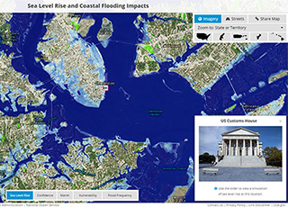
Sea Level Rise and Coastal Flooding Impacts Viewer
Using the best-available science and data, federal agencies developed a sea level rise planning tool to help state and local officials, community planners, and infrastructure managers understand possible future flood risks from sea level rise for use in planning decisions. This, and many other coastal GIS tools are available from NOAA's Digital Coast.
Prepare for and recover from environmental and natural disasters:
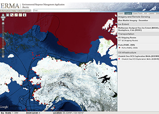
Environmental Response Management Application (ERMA®)
ERMA is an online mapping tool that integrates both static and real-time data, such as ship locations, weather, and ocean currents, in a centralized, interactive map for environmental disaster response. Having the latest information in an easy-to-use format provides managers with the data they need to make informed decisions.
Make ocean observations & coastal and marine weather available to mariners:
nowCoast
This GIS-based webmap service provides frequently updated ocean observations along with coastal and marine weather forecasts available 24 hours a day. Users can experience visual point-and-click access to 60 NOAA data products and services. This online tool provides the public with a one-stop-shop look at coastal conditions—real-time and forecast—before they do or plan anything on the water.
Improve data and location precision:
Continuously Operating Reference System (CORS)
Surveyors, GIS users, engineers, scientists, and the public that collect GPS data can use CORS data to improve the precision of their positions. The network of 1,800 CORS stations improves coordinates relative to the National Spatial Reference System, both horizontally and vertically.
 An official website of the United States government.

 supporting three-dimensional positioning activities")
Social