Survey towers were used by U.S. Coast and Geodetic Survey surveyors from the mid-1800s through the 1980s to obtain the clear lines-of-sight needed to conduct the surveys that are the backbone of our nation's spatial reference framework. One of the most enduring and widely used types of towers was the Bilby Tower, designed by Jasper Bilby in 1926.
What's a Bilby Tower?
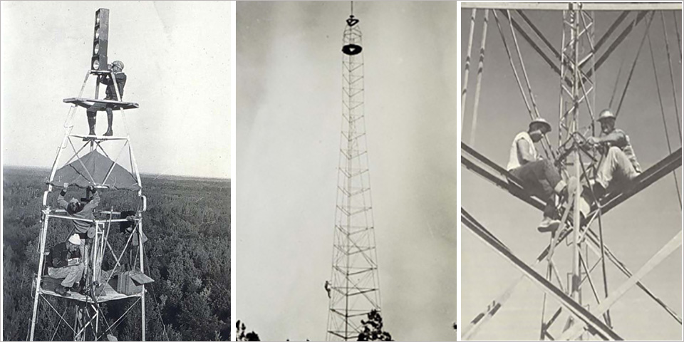
The Bilby Tower was actually two towers in one. The inner tower held the survey instruments, while the outer tower held the people—observer and recorder (or lightkeeper). The two towers never touched each other, which isolated the movement and vibrations caused by the people moving on the outer tower from the inner tower, thus protecting the survey instruments from movement.
NOAA's National Geodetic Survey and its predecessor organizations have been using geodesy to map the U.S. shoreline, determine land boundaries, and improve transportation and navigation safety for over two centuries.
Today, surveyors rely on the Global Positioning System, a constellation of satellites that transmit radio signals from space. When used according to special procedures, GPS receivers on Earth can determine position coordinates to centimeter-level accuracy (less than one-half inch).
However, surveying used to be a much more difficult earthbound endeavor.
Traditional survey methods require a clear line-of-sight between survey points. Intervening hills and tall trees can make obtaining a clear view challenging. Traditional surveying also involves the use of accurate instruments. To get the best measurements, these instruments must be stable — just walking around a survey instrument can disturb it sufficiently to degrade observations.
Over the years, the U.S. Coast and Geodetic Survey (C&GS), the forerunner of today's National Geodetic Survey and Office of Coast Survey, used and developed several innovative survey towers to raise the level of surveys and obtain clear lines-of-sight while stabilizing equipment.
One of the most famous — and most widely used — survey towers was developed by Jasper S. Bilby in 1926.
Meeting a Need
The first Bilby Tower ever built was constructed in Minnesota in 1927. Note the man standing on the very top of the tower!
Jasper S. Bilby, Chief Signalman, worked for the C&GS for over 50 years, from 1884 to 1937. In 1926, based on his familiarity with wooden towers, steel pipe towers used by the U.S. Lake Survey, the popular steel windmill towers of the day, and probably his having seen toy Erector sets, Bilby designed a portable, reusable, galvanized steel survey tower.
Prior to the Bilby Tower, most survey towers were being constructed from wood and a new tower had to be built over each survey mark. At the time Bilby designed his steel tower, wood was becoming very expensive and the time to build a tower from scratch was costly. In fact, in the much flatter eastern portion of the U.S., C&GS changed the type of surveys used from triangulation to the less-accurate traverse type of survey to avoid having to build expensive wooden towers.
Designed to Strict Standards
The Bilby Tower was designed to strict specifications, drafted by Bilby with help from the Aeromotor company, builders of windmill towers. According to Bilby: three essential requirements have to be satisfied to make the steel tower a success: First, the tower must have great rigidity and stability against vibration and against twist in azimuth; second, the tower must be so constructed that it can be readily erected and taken down; third, the total weight of a completed tower should preferably be light enough that a single moderate-sized truck can transport it from station to station. An additional requirement was that the tower needed to be designed so it could be constructed at different heights as individual circumstances required.
Putting the Tower to Use
Once the tower had been found to meet Bilby's specifications, the C&GS went on to use Bilby Towers for over 50 years, from 1927 to 1984. Other organizations that used the Bilby Tower included the U.S. Army Corps of Engineers, the U.S. Air Force, the U.S. Geological Survey, the Inter-American Geodetic Survey (in Central and South America), the Geodetic Survey of Canada, and the Ordnance Survey in the United Kingdom. The towers were also used to make a survey connection between England and France across the English Channel. The C&GS also used the towers on survey projects in other parts of the world and taught several state agencies how to use Bilby Towers.
After the Bilby Tower came into usage in 1927, C&GS surveys in the eastern U.S. reverted back to triangulation, increasing the accuracy of the national survey network. Bilby Towers were found to save about 75 percent of the cost of former wooden towers.
Bilby Tower Construction
Bilby Towers could be used in moderate winds, but they were not indestructible. Towers settled or were blown over by tornadoes and hurricanes.
The Bilby Tower was very fast to construct. A trained crew of five, with the right equipment but no crane, could set four survey marks and construct both inner and outer towers in just one day. The size of the tower pieces were designed so that one person could handle most pieces. The spacing between the horizontal pieces of the tower was also designed so that the builders could reach from one level to the next.
One of the builders was responsible for building each of the three legs of the tower. Each of the three "leg-men" had a construction platform (a small "A" shaped wooden seat nicknamed the "A-Board"), which rested upon two of the tower's horizontal ties and just inside a leg. The leg-man sat on the platform while bolting on the next leg (vertical piece) and stood on the platform while bolting on the next tie (horizontal piece). The fourth builder passed steel and tightened bolts. The fifth builder, the "Building Foreman," stayed on the ground, supervised, organized tower parts, and used the truck winch to raise steel to the height of the builders.
Disassembly of Bilby Towers was even faster. A team of builders could take down two towers per day.
During building, a winch drum mounted on the rear wheel of the jacked-up building truck was used to help raise steel parts up to the height of construction. Preparing for observations, survey equipment was hauled up the tower by an electric winch in the observer's truck.
Legacy
The ingenuity of Jasper Bilby in designing a tower that allowed surveyors to obtain needed clear lines-of-sight and accurate survey observations was enduring: the last Bilby Tower was built in 1984, over 50 years after it was first conceived by Bilby.
The towers represent important tools in surveying our nation and reflect the determination of surveyors dedicated to getting the job done…no tree or mountain was enough to stop these men from completing the surveys that today are the backbone of our nation's spatial reference framework, called the National Spatial Reference System.
 An official website of the United States government.


Social