Get information on the location and description of survey marks in your geographic area, and find out how to share your survey marking discoveries with the rest of the world!
National Geodetic Survey Satellite Triangualtion Program, illustrating the idea of modeling the Earth. Courtesy NOAA Geodesy
Imagine bridges not meeting in the middle... Airplanes landing next to runways instead of on them... Ships frequently running aground... This is just a glimpse of life without geodesy.
What’s geodesy? It’s the science of measuring the size and shape of the Earth and accurately locating points on the Earth’s surface (and is pronounced “gee - ODD - ess - ee”).
READ ON, and find out how geodesy can be a lot of fun!
Another way to think about geodesy is to imagine a world globe with a lot of pins stuck in it. Geodesy is about giving each of those pins its own “address” written as latitude and longitude. Why is this important? Because each of those pins can serve as a starting point for describing the location of any other point on Earth; just like when you want to tell someone how to get to your house, you give them a starting point that they know, like a road or a building. In the United States, these reference points are developed and maintained by NOAA’s National Geodetic Survey (NGS).
Hang on, we’re almost to the fun stuff!
So where are all those pins stuck in the globe? They are everywhere—more than 1,200,000 in the United States!
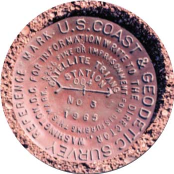
Of course, they really aren’t pins. Instead, NGS uses permanent marks called “survey marks” (you may hear survey marks called “benchmarks,” but benchmarks are only one type of survey mark). Often, survey marks are marked with a metal disk like the photo below, set in concrete or bedrock:
Survey marks can also be stainless steel rods driven into the ground, drill holes in bedrock, bottles, pots, or landmarks visible from a long distance, such as a water tower, a radio mast, or a church steeple.
Courtesy NOAA Geodesy Collection
Now for the fun: Although the majority of benchmarks are located in plain sight, they are usually ignored by the general public. Many benchmarks haven’t actually been visited in a long time, and no one knows whether or not they still exist. So if you find one of these benchmarks, so you may actually be rediscovering long-neglected objects of American history!
Searching for survey marks is called “mark recovery” and is a lot like a treasure hunt (you may hear this activity called “benchmarking” but the correct term is “mark recovery”). Hunting for survey marks can lead to interesting places like high mountain peaks, deep woods, old buildings, bridges, and sometimes, ghost towns! You can enjoy the excitement of being the first to find and document a long-lost survey mark; write a log for your discoveries on the worldwide web; and if you find a survey mark that hasn’t been recovered in a long time, you can submit a recovery note, with your name, to the NGS web site. Hunting for survey marks can be even more fun if you have a global positioning system (GPS) receiver. With GPS, you can go very close to the exact latitude and longitude of survey marks installed in your area. This is a kind of treasure hunt called “geocaching” (pronounced “GEE - oh - cashing”).
Here’s how can you find out about survey marks in your area, and try your survey mark hunting skills!
What You Will Need
Computer with internet access
(Optional) Digital camera (or phone) for photographing your discoveries
(Optional) GPS receiver (this is useful for getting close to a specific survey mark, but the actual “find” is usually done by using very detailed location descriptions from the survey mark’s datasheet)
Warnings:
Mark recovery should ONLY be done with an adult partner!!
Many survey marks are on private property, and may be in dangerous areas. Be sure to obey local laws!
How to Do It
The first step is to find out what survey marks are located in your area. The easiest way to do this is to use the search engine on the National Geodetic Survey website at www.ngs.noaa.gov. Click on “Looking for Bench Marks ” and the picture of the magnifying glass. This will open a page allowing you to search for survey marks using several different methods including the “Data Explorer” search engine - AKA the interactive map. Detailed instructions will appear when you open it. To find survey marks in your area:
Enter the county, city, or zip code for your area in the “Go To Location” menu, then click “Go”.
The map will zoom in to the area you specified. Colored squares show the general location of survey marks (if there are no squares, there are no marks in the specified area). You can change the radius of the area using the “Location radius” box. Click on one of the squares to zoom in further to show individual survey marks.
Click on one of the survey mark icons, and a summary window will pop up. Click on “Datasheet” at the bottom of the popup window to open the complete datasheet for the survey mark you selected.
Near the bottom of the Datasheet is a section titled “Station Description,” which may be followed by one or more sections titled “Station Recovery.” The “Station Description” section gives very precise instructions for finding the survey mark, starting from easy-to-find landmarks (such as a public building or the intersection of major roads). This description also includes information about things that may make it easier to find the survey mark, such as:
“30 FEET SOUTH OF THE CENTER LINE OF THE ROAD, 23.98 FEET WEST OF BENCH MARK 33 A (USGS), AND ABOUT 2 FEET LOWER THAN THE ROAD.” or “8 FEET SOUTHEAST OF A GATE IN AN EAST-AND-WEST FENCE, AND IN THE TOP OF A LAVA ROCK. A UNITED STATES GEOLOGICAL SURVEY STANDARD COPPER NAIL AND WASHER, STAMPED 5240.4.”
The “Station Recovery” section gives information about the condition of the survey mark at various times when the mark location was visited. This section can be very important, because sometimes it says that the mark was not found. This information can save you a lot of time spent looking for a mark that no longer exists!
Now see whether you can locate some benchmarks. Read the location descriptions carefully, and try to start in areas that are familiar. BE SURE TO DO THIS ONLY WITH AN ADULT PARTNER!
When you find a benchmark, you can take pictures, but that’s all! Never disturb or move a benchmark, even if it appears to have been damaged. Remember that benchmarks are important, they are public property, and are protected by law.
You can also log your find on the geocaching Web site. See www.geocaching.com/play for instructions.
If the location for survey marks is described as something like a radio tower, church steeple or smokestack, the top of these structures is usually the survey point. Do not climb these structures! Just log your find, and take the structure’s picture (from the ground!) if you have a digital camera.
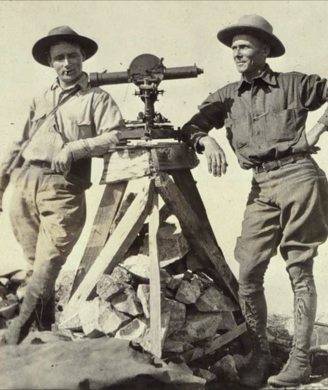
Members of a 1922 geodetic survey expedition. Until recent advances in satellite technology, namely the creation of the Global Positioning System (GPS), geodetic surveying was an arduous task best suited to individuals with strong constitutions, and a sense of adventure. Courtesy NOAA NOS Geodesy.
 An official website of the United States government.