Examine information about items found in and around the Stellwagen Bank shipwreck, and draw conclusions about the ship, who was aboard, and why the ship sank
Great acts of courage, senseless tragedy, the heroism of a captain, the greed of a stingy shipowner, the stupidity of a watchman all find their ways into the history of shipwrecks.
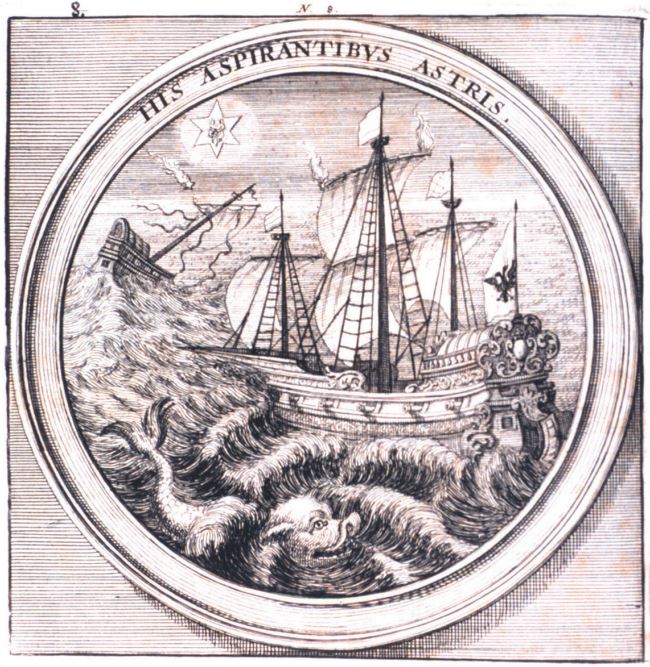
Storm, shipwreck, and sea monster. Archival Photograph by Mr. Sean Linehan, NOS, NGS
Shipwrecks are an important part of our nautical heritage. Some of our nation’s most interesting shipwrecks are found in NOAA’s National Marine Sanctuary System, including the remains of the Civil War ironclad, U.S.S. Monitor. Some shipwrecks are hazardous to other vessels. Nautical charts produced by NOAA’s Office of Coast Survey show the location of known shipwrecks and other hazards to navigation.
In September 2003, NOAA’s Office of Ocean Exploration and Research visited a newly discovered shipwreck in the Stellwagen Bank National Marine Sanctuary on the coast of Massachusetts. Underwater archaeologists studied the wreck to learn more about what happened to cause the ship to sink. Now it’s your turn to be a Wreck Detective!
What You Will Need
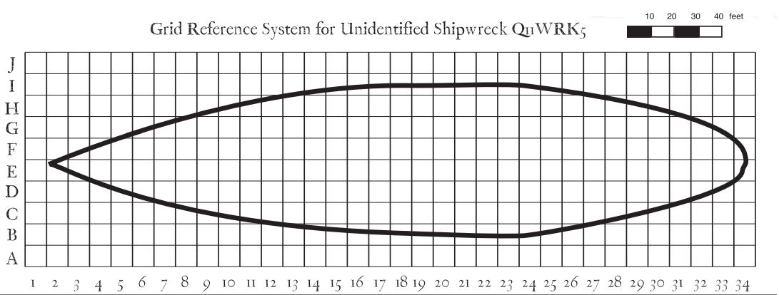
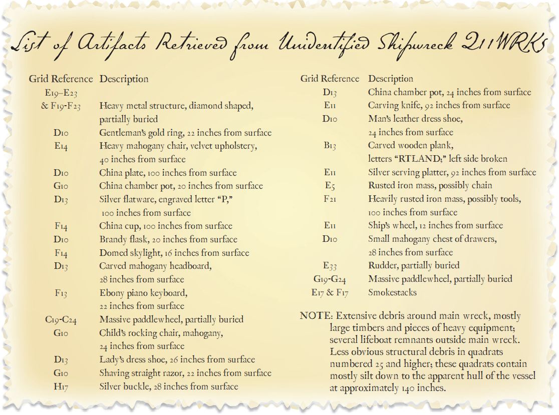
“Grid Reference System for Unidentified Shipwreck Q11WRK5” and “List of Artifacts Retrieved from Unidentifi ed Shipwreck Q11WRK5”
Imagination
How to Do It
Your first task is to organize information about where the artifacts were found on the shipwreck. The “List of Artifacts” gives a grid location for each item and how deeply artifacts were buried (so “22 inches from surface” means the object was buried 22 inches into the sea bottom). Archaeologists often use a grid system to precisely record the exact location of artifacts and their relationship to each other. You have already used grids to express location if you have ever played Battleship, or even Bingo.
As you look at the description of each artifact, think about how deep the artifact was below the surface, and what other artifacts were found nearby. Then consider what the artifacts may suggest about:
The specific identity of the ship that sank
The of the vessel
The vessel’s purpose
Who is aboard
Why the vessel sank
Write your conclusions on a piece of paper. Then read “The Story of the Steamship Portland” below.
Visit monitor.noaa.gov for information on the Monitor National Marine Sanctuary.
The Story of the Steamship Portland
On Thanksgiving Saturday, November 26, 1898, the passenger steamship Portland left Boston Harbor with more than 190 passengers and crew bound for Portland, Maine. The Portland was a state-of-the-art, luxury ship with velvet carpets, mahogany furniture, and airy staterooms. By 1898, paddlewheel steamboats had revolutionized transportation in the United States. Faster and more reliable than sailing ships, paddlewheelers could also maneuver in waters that were too shallow for sailing ships. By the 1870’s, many people routinely boarded steamboats to travel between port cities. But the paddle-wheelers had a serious flaw: they were built long and narrow (the Portland was 281 feet long and 62 feet wide), and this shape combined with a shallow draft (the Portland’s keel was only 11 feet below the water line) made these ships extremely unstable in high seas.
When the Portland steamed out of Boston Harbor, she ran straight into a monster storm moving up the Atlantic coast with northeasterly winds gusting to 90 mph, dense snow, and temperatures well below freezing. Facing a roaring northeasterly wind, the captain could not turn back; to have done so would have placed the ship broadside to wind and waves that would surely have capsized her. The only choice was to continue to head northeast into the waves, and hope to ride out the storm. Four hours after her departure, a vessel believed to have been the Portland was seen near Thatcher Island, about 30 miles northeast of Boston. But the Portland was apparently unable to make much more progress against the storm.
At 5:45 a.m. on the morning of November 27, four short blasts on a ship’s steam whistle told the keeper of the Race Point Life-Saving Station on Cape Cod that a vessel was in trouble. Seventeen hours later, life jackets, debris, and human bodies washed ashore near the the Race Point station, confirming that the Portland and everyone aboard had been lost in one of New England’s worst maritime disasters. The loss of the Portland underscored the inherent instability of sidewheel paddleboats. Sidewheelers were gradually replaced by propeller-driven boats, which have a lower center of gravity.
For 90 years, the location of the Portland wreck was unknown, despite intense and continuing public interest. In April 1989, members of the Historical Maritime Group of New England found wreckage in water more than 300 feet deep that they were certain had been the Portland. Because of the depth, however, the discoverers were unable to obtain photographs or other evidence that could confirm their find. Thirteen years later, on August 29, 2002, the U.S. Commerce Department’s National Oceanic and Atmospheric Administration (NOAA) confirmed that the wreck of the Portland had been found within NOAA’s Stellwagen Bank National Marine Sanctuary. Using side-scan sonar and a remotely operated vehicle (ROV), scientists obtained high-quality video and side-scan images in a joint research mission of the Stellwagen Bank National Marine Sanctuary and the National Undersea Research Center at the University of Connecticut.
Massive storms during late October and November are not particularly unusual in the New England states. At this time of the year, large cold air masses from Canada cross the midwestern states on a regular basis. At the same time, the Atlantic Ocean retains its summer heat and these warm waters sometimes spawn hurricanes. When the eastmoving cold air masses encounter the warm, humid oceanic air, the result is what New Englanders call “Nor’easters:” storms that are often severe, and are often the cause of maritime disasters.
Clues from the “List of Artifacts Retrieved from Unidentified Shipwreck Q11WRK5:”
The large paddlewheels near the middle of the ship clearly suggest a sidewheel paddleboat. This was a large vessel for a paddlewheeler; over 280 feet. The diamond shaped metal structure is probably the remains of a walking beam engine, a common design in ships of this type. The fact that this was a large paddlewheeler narrows its probable vintage to between 1890 and 1910. Artifacts in quadrats D10, D13, and G10 suggest that men, women, and children may have been aboard, and these areas may have been staterooms. The fact that artifacts in these areas were close to the surface suggests that these staterooms were on or near the deck of the vessel. Eating utensils recovered from more than 80 inches below the surface suggest a dining area, located on a lower deck. Engraved silver flatware and the carved wooden plank are valuable clues, suggesting that the name of the vessel may have begun with the letter “P” and ended with the letters “rtland.” Many of the artifacts suggest wealth and luxury. This vessel almost certainly carried some wealthy passengers.
Think about the size of the debris field. Ships that sink suddenly (such as those sunk in battle) often have a rather small debris field. Ships that sink with lots of movement, on the other hand (such as ships sunk in storms) are likely to have larger debris fields. This ship has an extensive debris field, suggesting that a lot of motion, possibly due to a storm, was involved in her sinking.
 An official website of the United States government.