SUPPORTS NOS PRIORITY: Preparedness and Risk Reduction
Coastal communities requested more than $135 million for projects to better manage natural hazards and restore habitats. More than 167 proposals were received, and 19 NOAA Coastal Resilience Grants were chosen to receive $13.8 million in federal funds. An additional $8.3 million in matching funds were added. The projects cover 17 states and Puerto Rico. More than 350 coastal communities will be impacted, and 1,100 acres of habitat will be restored and used to enhance flood protection. Projects include tsunami preparations in Oregon; marsh, oyster bed, and coral reef restoration projects in California, Oregon, Puerto Rico, Hawaii, and Rhode Island; nature-based infrastructure improvements in numerous states; flood-control and water-flow improvement projects in Massachusetts and New Hampshire; improved flood forecasts in Hawaii; and comprehensive disaster and recovery plans for Georgia. Coastal Resilience Grants, which integrate two grant programs within NOAA’s National Ocean Service and NOAA’s National Marine Fisheries Service, have provided project funding for coastal resilience work since 2015.
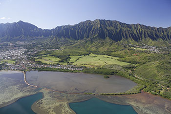
SUPPORTS NOS PRIORITY: Stewardship, Recreation, and Tourism
Hawaii is home to the nation’s newest member of the National Estuarine Research Reserve System, the He‘eia research reserve. Located on the windward side of O’ahu, the site contains over 13,000 acres of unique and diverse habitats, and joins the other 29 sites protected for long-term research, water-quality monitoring, education, and coastal stewardship.
The 1,385-acre He'eia National Estuarine Research Reserve , established on the island of Oahu in 2017, is the 29th site in the National Estuarine Research Reserve System (NERRS) and the first new reserve in more than six years. The reserve includes unique and diverse upland, estuarine, and marine habitats within the He'eia estuary and a portion of Kaneohe Bay, and protects a stream, coral reefs, sand flats, and important cultural sites such as traditional agricultural and heritage lands. The Hawaii Institute of Marine Biology at the University of Hawaii is NOAA’s local managing partner. The NERRS protects more than 1.3 million acres, hosts more than 450,000 annual visitors, and plays an integral role in NOAA’s efforts to improve the resilience of coastal communities and economies. NOAA supports education, community involvement, and conservation at each site, and provides program leadership, guidance, and funding.
SUPPORTS NOS PRIORITY: Preparedness and Risk Reduction
The Office for Coastal Management is managing a 5-year contract to successfully address issues such as sea level rise and flooding impacts in coastal communities that need specialized data and technical assistance. The contract provides communities with red-tape-free access to some of the country’s top geospatial firms. Local, state, and federal agencies use the contract to purchase a wide variety of services, including LIDAR, imagery, and acoustic data; thematic mapping; and GIS data and assistance. All data are accessible through NOAA’s Digital Coast.
SUPPORTS NOS PRIORITY: Stewardship, Recreation, and Tourism
The National Estuarine Research Reserve System developed a powerful new approach to evaluate and compare the ability of tidal marshes to survive rising seas. The methodology, which measured five categories of resilience, was implemented at 16 research reserves in the first nationwide study of its kind. Virtually every marsh had at least one low score indicating a vulnerability, but most had moderate overall scores. Marshes along the Pacific Coast appeared more likely to survive sea level rise than those along the Atlantic Coast. The methodology will be used to test and monitor changes over time, and other organizations can use it to standardize the approach, making wider comparison studies possible.
SUPPORTS NOS PRIORITY: Preparedness and Risk Reduction
The Office for Coastal Management’s Digital Coast Academy launched the course “Building Risk Communications Skills,” which is quickly becoming one of the academy’s most popular offerings. The course explains how people respond to risk, why they respond the way they do, and instructs participants in the skills needed to communicate with a variety of audiences. Such skills can lead to a higher level of community engagement and increase the number of people and organizations motivated to reduce risk. A risk communications guidebook was also developed.
 An official website of the United States government.
Here's how you know we're official.
An official website of the United States government.
Here's how you know we're official.