SUPPORTS NOS PRIORITY: Safe and Efficient Transportation and Commerce; Preparedness and Risk Reduction; Stewardship, Recreation, and Tourism
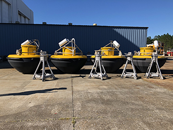
Line of tsunami buoys ready for deployment at the NDBC facility in Mississippi. Building a sustainable national network of buoys and underwater moorings is the goal of the Strategy for a National Moorings Network, released by U.S. IOOS and NDBC in 2017. Credit: Victoria Kromer
NOAA released the first National Strategy for a Sustained Network of Coastal Moorings to identify, preserve, monitor, adaptively manage, and integrate a moorings network operated by federal and nonfederal entities. The U.S. Integrated Ocean Observing System (IOOS®) and the National Data Buoy Center led the strategy, which establishes a framework for planning and implementation and enables integrated stakeholder engagement through peer review and input into network architecture and design. Data from moored instruments benefits public safety and the economy, because fisheries, marine industry, tourism, and the military rely on observing data to operate effectively. As an example, buoy data from the Gulf of Maine buoy network underpins the Gulf of Maine lobster forecast, which supports the $660 million U.S. Northeast lobster industry. The Northeastern Regional Association of Coastal Ocean Observing Systems (NERACOOS, an IOOS regional association), which operates the network, is using the strategy to ensure that moorings are operated and maintained where they are needed, while also developing a public/private infrastructure that will allow for uninterrupted deployments.
SUPPORTS NOS PRIORITY: Preparedness and Risk Reduction; Stewardship, Recreation, and Tourism
A bulletin to inform communities and combat the impacts of harmful algal blooms (HABs) in the Pacific Northwest went operational this year. Real-Time HABs, funded by the National Centers for Coastal Ocean Science and the National Marine Fisheries Service, integrates data from the U.S. Integrated Ocean Observing System (IOOS®) and is hosted by the Northwest Association of Networked Ocean Observing Systems (NANOOS, an IOOS regional association). The model- and observation-based HAB forecast is supported by data from IOOS, the University of Washington’s LiveOcean model, sampling by state and tribal groups, and other real-time observations. The bulletin also uses data from the Environmental Sample Processor (ESP), deployed near the Juan de Fuca eddy, a known HAB "hot spot." The ESP is an automated biosensor that collects and analyzes water samples every few days and transmits the data back to researchers. Developed by the Monterey Bay Aquarium Research Institute and supported by an IOOS Ocean Technology Transition Grant, the ESP is deployed in the Pacific Northwest and the Gulf of Maine to measure potentially harmful phytoplankton species and the toxins they produce.
SUPPORTS NOS PRIORITY: Preparedness and Risk Reduction; Stewardship, Recreation, and Tourism
The Nutrient Sensor Challenge, a market-based competition designed to spur innovation, announced that Systea, S.p.A, was the winner for its instrument that measures both dissolved nitrate and phosphorus nutrients in an integrated, cost-effective package. The U.S. Integrated Ocean Observing System (IOOS®) partnered with the Alliance for Coastal Technologies (ACT) to conduct the competition, which challenged companies to develop sensors to measure dissolved nitrate and/or phosphorus content with a purchase price at or below US $5,000. Nutrient pollution—the overabundance of essential nutrients like nitrogen and phosphorus—costs the U.S. $2.2 billion annually and threatens human and economic health. Less expensive, new-generation sensors will help expand research and operational monitoring opportunities, thereby improving the nation’s ability to manage risks to public safety and forecast potential events. Building on that success, an interagency team launched the Nutrient Sensor Action Challenge to unite innovative sensor and data projects with ongoing nutrient pollution problems. By demonstrating successful strategies for incorporating nutrient sensors into existing water monitoring efforts, the Challenge can help states and communities take action to prevent and reduce nutrient pollution.
SUPPORTS NOS PRIORITY: Safe and Efficient Transportation and Commerce
As cargo ships grow to keep pace with global demand, ports are increasingly in need of accurate, real-time information on conditions to operate effectively. Close monitoring of under-keel clearance—the space between the ship and the seafloor—is critical to safely managing port traffic. The Southern California Coastal Ocean Observing System (a regional association of the U.S. Integrated Ocean Observing System, IOOS®), NOAA’s Office of Coast Survey, and Jacobson Pilot Services, Inc., teamed up with the Port of Long Beach to build out the observing infrastructure around the port and provide integrated data to support safe navigation of deep-draft ships. The port, in turn, worked with an industry expert to present NOAA’s data on an accessible, real-time software platform. The effort’s flagship success came in April 2017, when the Captain of the Port increased the draft limit from 66 feet to 67 feet, with a long-term goal of reaching 69 feet. This approach has the potential to reduce lightering costs—the cost of removing cargo from the ship before it reaches port to decrease the draft—which run nearly $10 million per year, while effectively managing the risk of grounding. NOAA is considering how the approach might be applied at other U.S. ports.
SUPPORTS NOS PRIORITY: Stewardship, Recreation, and Tourism
In spring 2017, a multi-institutional partnership led an experiment in California’s Monterey Bay to test a comprehensive, interdisciplinary automated underwater vehicle (AUV) research system. The network would enable an autonomous coastal observation system to direct robots to sample in and around fronts and other oceanographic features, and return accurate, real-time data and models to researchers and resource managers. This would allow sampling and surveying independent of scheduled experiments and research cruises, which can miss short-lived but important biological events. A fleet of five long-range AUVs, supported by four profiling gliders and a wave glider, were deployed to map the environment as part of joint research cruises by the Monterey Bay Aquarium Research Institute (MBARI), Marine Biodiversity Observing Network, and NOAA’s National Marine Fisheries Service. The sampling locations targeted fronts and upwelling plumes, guided in near real time by the autonomous vehicle fleet. One MBARI AUV was outfitted with an environmental sample processor to collect Environmental DNA samples simultaneously with net tows and hydrographic samples. The Central and Northern California Ocean Observing System (CeNCOOS, a regional association of the U.S. Integrated Ocean Observing System, IOOS®), provided data management support. NOAA’s Monterey Bay National Marine Sanctuary, as an active partner with MBARI, MBON, and CeNCOOS, is developing interactive websites to share these data sets with managers and inform condition reports on the health of the sanctuary.
SUPPORTS NOS PRIORITY: Safe and Efficient Transportation and Commerce; Preparedness and Risk Reduction; Stewardship, Recreation, and Tourism
In FY 2017, the U.S. Integrated Ocean Observing System (IOOS®) continued its program to certify its regional associations (RAs) as Regional Information Coordination Entities (RICEs). RICEs are nonfederal observing organizations that are recognized as meeting federal standards for data gathering and management. Certification requires the RA to operate inclusively, transparently, and seek user input to determine system priorities; to submit rigorous documentation of its standards and practices, and work closely with IOOS to meet all goals; and to publish documentation that lets outside users apply the RA’s data to other projects. Once an RA is certified, its RICE data has the full backing of IOOS and NOAA. Certification benefits the full system by expanding the pool of available federal-quality observing data to include local assets. As of FY 2017, seven of IOOS’s 11 RAs have been granted RICE status, with the remaining four RA applications in the review process.
 An official website of the United States government.
Here's how you know we're official.
An official website of the United States government.
Here's how you know we're official.