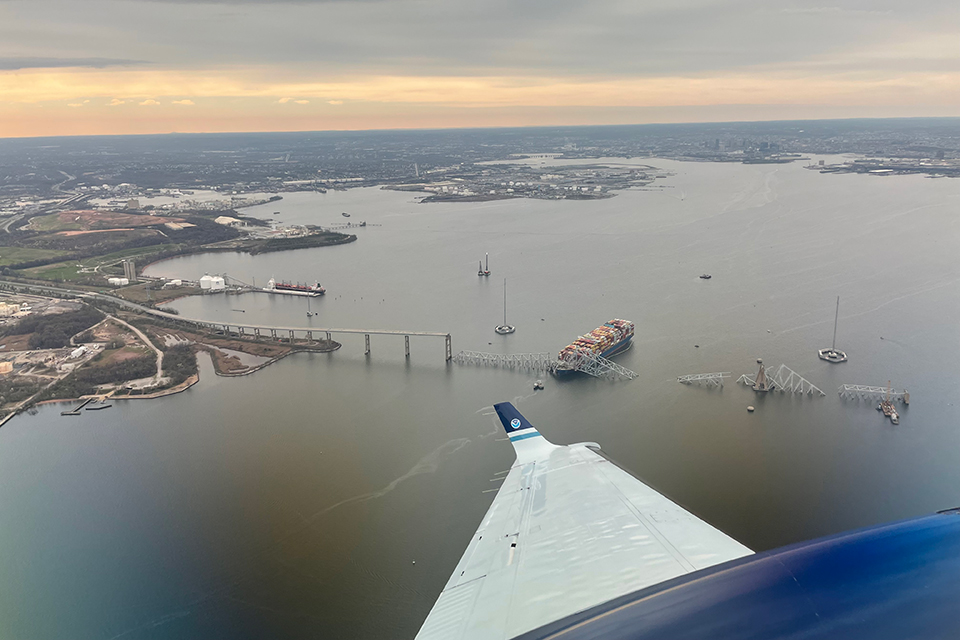
March 28, 2024: View from NOAA King Air N68RF aircraft during a navigation survey following the collapse of the Francis Scott Key Bridge in Baltimore, Maryland. The bridge and the M/V Dali, the container ship involved in the incident, are visible. (Image credit: Lt. Eric Fritzsche/NOAA Corps)
The nation continuously looks to the National Ocean Service to provide trustworthy and reliable expertise — particularly when we face an emergency. On Tuesday, March 26, the cargo ship Dali allided with the Francis Scott Key Bridge in Baltimore, Maryland, resulting in the bridge’s collapse and tragic loss of life. I offer my sincerest condolences to all those affected. The incident also disrupted essential infrastructure services, and NOS teams immediately deployed to the scene to provide valuable response and recovery capabilities. The tragedy took place close to the communities in which we work and live. While a Federal Emergency Management Agency disaster has not been declared, all four of National Ocean Service’s Mission Essential Function offices have provided rapid, critical support to this effort, and I commend NOS teams for their agile and committed service. The following is an overview of our activities in support of Francis Scott Key Bridge response and recovery efforts.
National Geodetic Survey (NGS)
The National Geodetic Survey (NGS) conducted flights to collect imagery of the Francis Scott Key Bridge and the surrounding channel to support hazardous material removal, marine debris collection, and other coastal management needs. The flights also produced expedited, updated information about the shoreline around the bridge. The collected data enabled the charting of the remaining bridge piers to establish an auxiliary channel and contributed to a NOAA Electronic Navigation Chart (NOAA ENC®) update. The data was shared with the appropriate local, state, and federal agencies responding to the event and conducting recovery efforts. The high-resolution imagery will also serve as the event’s baseline dataset and help inform anticipated engineering and debris removal efforts.
Office of Coast Survey (OCS)
The Office of Coast Survey (OCS) completed hydrographic surveys to establish safe alternate routes for shallow-draft vessels around the Francis Scott Key Bridge wreckage. The response team surveyed the waters on the north side of the main channel as well as the width and height of the bridge span, through which an alternate route would pass. The hydrographic survey data allowed the U.S. Coast Guard, or USCG, to identify a safe alternate route and open it to traffic on Monday, April 1. The navigation response team also surveyed the waters and bridge structure on the south side of the channel to allow the opening of another alternate route for vessel traffic on Tuesday, April 2.
OCS updated the area’s official NOAA ENC® with the latest data from the NGS’s aerial imagery, the survey data from the navigation response team, and buoy positions from the USCG. OCS is publishing daily updates to the NOAA ENC as new data is available and validated.
This combined effort to restore vessel traffic in and out of the Port of Baltimore and support response operations has been conducted in close collaboration with USCG and the U.S. Army Corps of Engineers, and it is consistent with NOAA's safety of navigation and nautical charting responsibilities and authorities.
Office of Response and Restoration (OR&R)
The Office of Response and Restoration’s (OR&R’s) Disaster Preparedness Program activated the NOS Incident Management Team to collect information and enhance coordination across the National Ocean Service with regard to personnel, mission, infrastructure, and response and recovery activities and to support messaging up to NOAA leadership and beyond. The mid-Atlantic NOAA scientific support coordinator responded on-scene to support the initial USCG pollution control and abatement operations early in the response and continues to support as needed. The NOAA Marine Debris Program is also available to support as needed.
Office for Coastal Management (OCM)
Office for Coastal Management (OCM) staff assisted a member of the press with vessel tracking data available on the Digital Coast’s Marine Cadastre website. OCM staff also extracted a data subset for the Baltimore area. OCM received feedback stating, "This repository of [AIS] data is so valuable, a great resource for researchers and the public. Thank you for maintaining it and making it easy to access."
Center for Operational Oceanographic Products and Services (CO-OPS)
The Center for Operational Oceanographic Products and Services (CO-OPS) is supporting the NOS Incident Management Team. On April 4 CO-OPS responded to a request for response and recovery data, or gauging support, and deployed a short-term currents buoy, or CURBY. This buoy is now moored in the Patapsco River just north of the bridge, delivering real-time currents and meteorological data. An existing CO-OPS meteorological station positioned adjacent to the Francis Scott Key Bridge continues to operate as normal. Data for all stations can be accessed via NOAA's Chesapeake Bay North PORTS webpage and via CO-OPS Data API. CO-OPS maintains a hydrodynamic model for the Baltimore region called the Chesapeake Bay Operational Forecast System, or CBOFS, that provides forecast guidance on water level, currents, salinity, and water temperature. In collaboration with the U.S. Integrated Ocean Observing System, CBOFS output is in a publicly accessible and interactive format, accessible here. CO-OPS subject matter experts are available at tide.predictions@noaa.gov to provide tide and tidal current predictions and CBOFS forecast guidance. CO-OPS experts will also interpret water level, tides, and currents patterns in and around Baltimore Harbor during response and recovery efforts in collaboration with the USCG and the OR&R.
Nicole R. LeBoeuf
Assistant Administrator, National Ocean Service
 An official website of the United States government.

Social