Vertical Mapping and Atomic Clocks
Making Waves: Episode 131
Scientists at the National Institute of Standards and Technology, or NIST, are developing atomic clocks that are so accurate that the effects of the general theory of relativity come into play. That means if two of these clocks are at slightly different elevations—even a few centimeters—the higher clock runs noticeably faster. In this episode, find out why this is a problem for NIST, how the National Geodetic Survey helped to solve this problem, and how these amazing atomic clocks may someday play an important role in the science of geodesy.

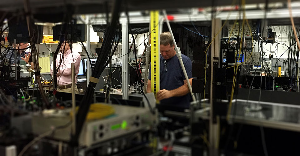
NOAA geodesist Steve Breidenbach holds a vertical leveling rod on top of a geodetic marker in the floor of a laboratory that contains several atomic clocks at the National Institute of Standards and Technology in Boulder, Colorado. Another geodesist (not pictured) measures the height of the rod relative to a known height. NGS scientists also used a gravity meter at this location. The height and gravity together are used to determine the geopotential at that mark. In this way, the geopotential at the clock locations (seen on the optical benches surrounding Breidenbach) can be determined relative to each other and to the geoid.
Listen to the Episode:
Transcript
HOST: This is the Making Waves podcast from NOAA’s National Ocean Service. I’m Troy Kitch, and I’m producing this episode on the NOAA campus in Silver Spring, Maryland, which …. according to my smartphone, is at an elevation of 340 feet. For me and for most of us, this smartphone measurement is good enough. But sometimes people need more precise elevation measurements … for things like mapping floodplains, building bridges and highways, navigation. And sometimes we need to calculate the most precise elevation measurements possible with modern technology. And we’ve got a great example of that to share in this episode.
HOST: We’re joined by Derek van Westrum, a scientist with NOAA’s National Geodetic Survey, who spent a good deal of time over the summer of 2015 working on a really cool project to determine the precise elevation of several atomic clocks at the National Institute of Standards and Technology, or NIST, in Boulder, Colorado. This is needed because these clocks are so unbelievably accurate that the effects of the general theory of relativity come into play. That means if two of these clocks are at slightly different elevations … even a few centimeters … the higher clock runs noticeably faster. Stay tuned to find out why this is a problem for NIST, how the National Geodetic Survey helped to solve this problem, and how these atomic clocks may someday play an important role in the science of geodesy.

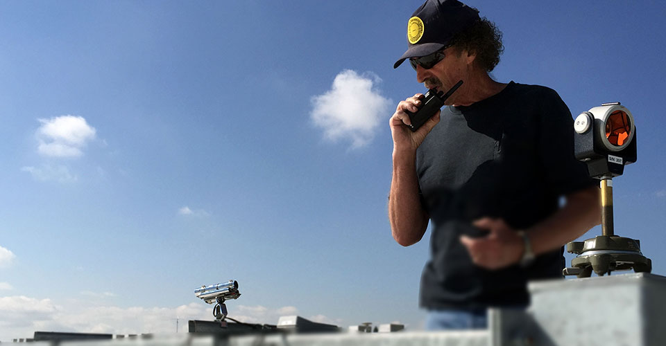
NOAA geodesist Roy Anderson sets up a retro-reflector, or prism, on the roof of a laboratory at the National Institute of Standards and Technology in Boulder, Colorado. The prism is one of many tools used to determine precise height at a given location.
DEREK VAN WESTRUM: “My name is Derek van Westrum. I’m a geodesist with the National Geodetic Survey and I’m stationed out here in Boulder. My background is actually physics and so, yeah, that’s me in a nutshell.”
HOST: Most people know what physics is, or at least have heard of it. But geodesy, not so much. Geodesy is the science of accurately measuring and understanding the Earth's geometric shape, orientation in space, and gravity field. That’s what the National Geodetic Survey — which we call NGS for short — is all about. And it’s quite a complicated problem. How do you measure this? How do you make sure we’re all measuring the Earth the same way? How do you keep measurements updated since the Earth is always changing? Here’s Derek:
DEREK VAN WESTRUM: “What do you call zero? Where do you start? How do you get your head around this problem of, OK, what’s changing relative to what? It’s a fascinating problem that people have been working on for almost 400 years now. How do we precisely describe and then measure the shape of the planet? And then, as you mentioned, there’s things like changes in the shape of the planet that you’ve got to put on top of that and keep track of.”
HOST: Measuring and keeping track of the gravity field for the nation is a big part of what NGS does … and it’s Derek’s expertise. This is the part of geodesy that deals with mapping the planet’s elevations, or as geodesists call it, vertical mapping. He said that most people think of Earth as a sphere. But because it’s spinning, it actually flattens out into an elliptical shape. Gravity is higher at the poles because the poles are closer to the center of the Earth, and lower at the equator because the equator is farther away from the center of the Earth . Things get really complicated when you add in mountains and other features around the Earth that cause variations in the gravity field. So goedesists like Derek use gravity measurements to map this out. One of the most important tools used to do this is called a gravity meter. Before we get to those atomic clocks, we need to know a bit more about this.
DEREK VAN WESTRUM: “Gravity and height, together, are the fundamental aspect of everything we’re really trying to do at NGS in terms of height measurements. Everybody thinks, “Yeah, gravity is constant, right?” Well, it turns out that, at first approximation it is, but as Newton tell’s us, as you get farther away from a source, gravity is weaker. So, for example, if you go up a mountain, gravity should be less because you’re farther away from the center of the Earth. And sure enough it is. And the gravity meters we have, if you lift them up a few millimeters, gravity will be noticeably weaker because you’re further from the center of the Earth. So that’s why one of the main things NGS does is to use gravity meters, to look for those changes in height, really. So, again, height and gravity really do go together.”
HOST: Derek said that “geopotential” is actually what is being measured with a gravity meter — and that’s a scientific term that you can think of as height adjusted for gravity. Gravity has to be accounted for when taking elevation measurements because, as he said, the Earth's gravity isn’t constant — it varies from point to point. He likes to describe this with a thought experiment:
DEREK VAN WESTRUM: “If you have a flat, dry lake and everything looks uniform, and you poured a bunch of water in the middle, it would just sit there. But if there was a blob of gold or something really heavy underground at one end of the dry lake, it would actually pull the water towards it. So what the water is really seeing there, if everything else is flat, the water shouldn’t move. It’s ‘seeing’ the gravity part and the height part. So the pulling of the water is the water going from a lower potential to a higher potential. So now you can see that things get confusing. With words like ‘flat’ or ‘level’ or ‘up’ or ‘height’ start to need to be really well defined. So that flat lake, it’s ‘flat’ meaning if you put a ruler on it, there’s no gaps anywhere, but it’s not level. The water wants to go towards the gold blob. So now when we talk about ‘geodetic leveling,’ you really are looking at changes in heights times the change in gravity at that point. And that’s a geodetic survey measuring geopotential. And the easiest way to think about is that’s what water ‘sees’.”
HOST: Now let’s return to what Derek and a team of NGS experts were doing at the Boulder, Colorado, campus of NIST—the National Institute of Standards and Technology. Among the many important functions of NIST is the measurement of time. Not just any old measurement … a NIST atomic clock serves as the nation’s civilian time and frequency standard — in other words, it’s the official time for the country. The frequency standard that you’re going to hear Derek mention in a moment is the natural resonance frequency of the cesium atom, which is how the measurement of one second is defined.
DEREK VAN WESTRUM: “At NIST, we’re doing a geopotential survey of their atomic clock labs. They have a frequency standard that’s based on cesium and it’s accurate to one part in 10 to the minus 15, which is a lot of zeros. It’s a very accurate clock. But there’s a new generation of these clocks that are actually a thousand times better than that, and they’re so good that some annoying effects start to show up. Einstein’s general theory of relatively predicts that if you take any clock and you lift it up — up is away from a source of gravity — so up from the center of the Earth, it will run faster. That’s just a weird general relativity effect. So the new clocks are so accurate that if you actually lift it up a centimeter or two, it will run noticeably faster. So that’s really pretty cool, but it’s also annoying if you’re trying to build one of these clocks, test these clocks. If you have two of them next to each other, and you want to compare them, again, if one is higher by a centimeter or two, you need to take that into account to make sure the clocks are actually agreeing with each other.”
HOST: So a simplified version of what Derek’s team did is measure the heights of the labs that contain the NIST atomic clocks so that when their scientists compare the clocks they can see how well they agree.
DEREK VAN WESTRUM: “But then the interesting part is, eventually they want to make these new, experimental clocks the standards and they want to compare with the clocks, say, in Paris or one of the world’s other standard locations, they need to know the geopotential difference between Boulder and Paris. So what we gave them is the value of the geopotential of, say, relative to something like sea level, and that will allow them in the future when they link to a clock in Paris, to know exactly what corrections need to be made so that they’re comparing apples with apples.”
HOST: Just how precise are the NOAA elevation measurements of the Colorado labs? As precise as we can get with today’s technology. I asked Derek if this kind of precision is typical in the day-to-day work of the National Geodetic Survey.
DEREK VAN WESTRUM: “In any survey, if you want to call that, any project, we look at what is needed. What kind of accuracy specs are someone going to need? So in Yellowstone, you want to look for the ground going up and down by, say, a centimeter or so over a few years. So you need pretty precise gravity meters for that and GPS running for many days. For other surveys, you can relax those. If you’re trying to level a road across some raw ground, maybe you only need a few centimeters. You can have shorter GPS measurements. For the NIST clock, we actually went to the highest specs we could possibly get. So to do the survey we had our most accurate gravity meter, we ran it overnight to average out tide signals from the sun and the moon. For the leveling, which is what most people think of as height, we picked three first-order bench marks — these are places that are already measured and established. We made sure they were self-consistent with each other and then we established these new heights to the best precision we could. So that’s something like a few millimeters over a few kilometers. It’s an astonishing precision to do the heights. And then the gravity is known to about nine digits, which is state-of-the-art, best you can do. In this case, we pulled out all the stops to do the most precise job we could.”
HOST: So now you have a sense for how geodesists can get very precise elevation measurements … and it’s a tricky business. Derek said that for many people, that these things are even possible is surprising.
DEREK VAN WESTRUM: “The thing that most people don’t realize is the astonishing precision of all these instruments. That you really can measure gravity or you really can level something to a few millimeters over a lot of kilometers. And then the fact that you can do fascinating things with that. You can watch mountains go up or down, you can watch the entire north part of the continent uplift, the fact that there’s actual a useful stuff that comes out of these things I think is surprising to a lot of people.
HOST: And here’s one other surprising thing that ties back to the atomic clocks we’ve been discussing. You know how the clocks are so sensitive that they noticeably speed up when raised only a few centimeters off the ground? Well, geodesists are pretty excited about that. Someday they might be able to use the atomic clocks developed by NIST to measure height changes at points around the nation in real-time.
DEREK VAN WESTRUM: “One of the goals of the NIST project is not only to help NIST out with their atomic clocks, but the hope is that one day we may be able to reverse that process and if somehow these clocks became portable and you could station them around the continent, you could leave one, say, down near sea level and link it with a clock, let’s say at Yellowstone, and you’ll see the one clock run faster or slower compared to other clock and you can look at direct changes in geopotential which, again, is the fundamental thing we’re interested in directly. Too my scientist buddies, if I told them that there actually are applications of general relativity where we could take atomic clocks and use them to measure real-time changes in the shape of the Earth … that there’s a practical application for general relativity. It’s a very cool thing.”
HOST: Well, you could say that we’ve only scratched the surface of the potential of measuring geopotential. There’s a big, long-term project that Derek and many others in NGS are involved with called the Gravity for the Redefinition of the American Vertical Datum, or GRAV-D. The goal is to use gravity measurements to refine a complex mathematical model of the Earth's shape that's known as the geoid. When this new model is ready for business in about seven years, it's expected to revolutionize how we measure heights. Soon, we may be able to use a GPS receiver to get our current elevation within an accuracy of two centimeters or less in most places across the nation. We’re going to bring you much more on this story in 2016 on the National Ocean Service website.
HOST: But that’s all the time we have for today. Thanks to geodesist Derek van Westrum from NOAA’s National Geodetic Survey. He joined us from his office in Boulder, Colorado. You’ve been listening to Making Waves from The National Ocean Service, coming to you from an elevation of about 340 feet.

From corals to coastal science, catch the current of the ocean with our audio and video podcast, Making Waves.
Subscribe to Feed | Subscribe in iTunes