Hurricane Season: Response and Preparedness
NOAA Ocean Podcast: Episode 16
June 1 is the start of the Atlantic hurricane season. Are you prepared? To help, learn the many ways the National Ocean Service responds to hurricanes, as well as easy steps you can take to be ready for whatever the season brings.
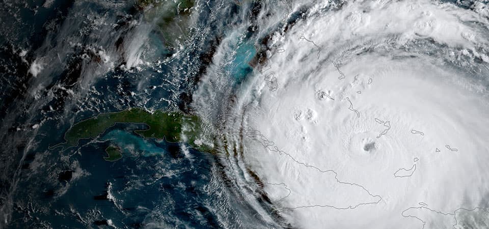
A satellite image of 2017's Hurricane Irma from NOAA's National Environmental Satellite, Data, and Information Service.
Transcript
HOST: It’s time for a NOAA Ocean Science Moment…I’m Megan Forbes. With Atlantic hurricane season starting in a few weeks on June 1st, we’re taking this moment to talk about Hurricane Preparedness and Response. Most people know that NOAA’s National Weather Service plays a central role when hurricanes threaten our coasts…but you might also be interested to learn that the National Ocean Service plays many roles in hurricane response. But first – let’s take a moment to talk about things YOU can do to prepare. It is not uncommon for the word hurricane to cause some anxiety in those who live along the coast and in areas that might be impacted. As we have seen in the past few years, large storms like these can make their way a considerable distance inland. However, being prepared for impacts can go a long way toward feeling ready for whatever a hurricane may bring. Here are a few easy things you can do to be prepared for this season:
Make a hurricane plan - know where to go if you are ordered to evacuate. Put together a go-bag or disaster supply kit, make an emergency communication plan, sign up for emergency text or email alerts, and prepare your home and property ahead of time. Guidance for all of these steps and more can be found at ready.gov/hurricanes
Now that we’ve covered that let’s talk a bit about what NOAA’s Ocean Service does in hurricane response before hurricanes hit the coast, when they hit, and long after the storms pass. Here’s NOAA Ocean’s Troy Kitch with the details:
TROY KITCH: One critical service the NOS provides is near real-time ocean and weather observations at locations affected by tropical storms from the National Water Level Observation Network. This network is made up over 200 stations around the country that continuously monitor water levels. During coastal storms, water levels can rise to flood levels. So it’s of course good to know and predict how high these water levels are going to get. You may want to check out an important product created from the data collected by the network … it’s called the Storm QuickLook. And as the name suggests, when a tropical storm forms, the QuickLook provides a real-time view of a storm’s impacts on coastal storm water levels, winds, and barometric levels. It’s mostly used as decision support tool by Federal, State and local emergency managers to assist evacuation and road closing decisions, but you too can see the data to monitor and prepare for storm conditions. QuickLook reports start coming out after the National Hurricane Center identifies a tropical system. The first of the reports arrive about 24-48 hours before a storm is projected to make landfall, and they continue to come out until the coastal impacts of the storm have receded, sometimes well after the storm has passed. The report also provides details about the storm tide associated with the storm. Storm tides are the number one cause of storm damage, so you can see why this is good information to know.
HOST: Troy goes on to tell us that the Ocean Service also is highly involved in the response to a hurricane AFTER the storm hits…
TROY KITCH: NOS also plays a lead role in navigational surveys, aerial photography surveys, and hazardous spill response. After a hurricane strikes, emergency Navigation Response Teams help get ports and waterways back open as fast as possible. They use sonar and divers to check for obstructions and hazards to navigation. This work is critical – not only does it help get our waterways and ports flowing again so supplies can get to the people who need them in these areas, it also helps to get commerce back up and running in the region. And while these teams are out doing their work, they’re also collecting data that they’ll use to update navigational charts for the area that mariners rely on.
Next up, let’s talk about aerial surveys. Many people don’t know this, but the ocean service begins flying survey missions to take pictures of coastal areas hit by a hurricane just days after the storm strikes and makes the photographs available on the internet to help those most affected by the hurricane determine if their homes, businesses, and properties had been damaged or destroyed. And finally, the NOS plays a major role after a hurricane hits by responding to hazardous material spills to survey vessels, pipelines, wells, or containers that may be leaking hazardous fuel, oil, or chemicals. And they fly on missions to locate and track offshore sources of spills. This data is combined with current weather and water conditions to develop computer models to help predict spill movement and to figure out where the greatest pollution threats are likely to occur. Added to this, the office lends a hand with vessel salvage, shoreline cleanup, and helping to understand how spills will affect natural resources in the region. Scientists and economists also assess the injuries done to natural resources caused by hazardous spills, grounding and debris in the area.
So the Ocean Service plays a big role in the immediate aftermath of a hurricane, but the work doesn’t stop there. For weeks, months, and even years after a hurricane hits the shores, the work continues to better understand the effect of the hurricane, in recovery planning, and in monitoring the effects of contaminants released from the storm on the environment. Long after the storm strikes, there are many big questions that need answered: what is the economic impact of the storm? What is the ecological impact – the cost to the environment? Where is the debris concentrated? How much wetlands were lost? These products can include everything from aerial imagery of the affected region from before and after the storm, digital elevation data to measure how the coastline changed as a result of the storm, to long-term recovery plans. But, I want to highlight one very cool hurricane-related product produced by this office. It’s called the online Historical Hurricane Tracks. This tool helps get a quick picture of coastal areas with the greatest frequency of hurricanes and tropical storms—and that historical “snapshot” can help community members and local emergency managers develop better plans for storm preparation and recovery.
HOST: Thanks for taking time for this NOAA Ocean Science Moment! Hopefully you now have a better idea of some of the many products and services offered by the National Ocean Service in support of hurricane response. Our main goal is to let you know this information is out there, online, and available for free. Atlantic hurricane season starts June 1st and runs through the end of November, and regardless of what the NOAA forecasts predict for this season, the main thing to keep in mind is that it’s time to start thinking about being prepared. You can find all of these resources and more at oceanservice.noaa.gov. Until next time, thanks for listening!

From corals to coastal science, connect with ocean experts to explore questions about the ocean environment.
Subscribe in iTunes | Subscribe to Syndicated Feed
Browse All Episodes of the NOAA Ocean podcast