Picking the Right Spot: Offshore Wind Energy
NOAA Ocean Podcast: Episode 2
How NOAA scientists use marine biogeography—the study of marine species, the geographic distribution of their habitats, and the relationships between living organisms and the environment—to help locate the best sites to place potential future alternative energy sites in the ocean.

This map shows how data points (left) are turned into spatial predictions (right). This example shows where humpback whales have been sighted and where they are predicted to be in the winter.
Listen to the Episode:
Transcript
HOST: You're listening to the NOAA Ocean Podcast. I'm Megan Forbes and in this episode we're talking about NOAA's role in Offshore Wind Energy. The quest for renewable energy, or energy that has been collected from resources which are naturally replenished over time, has led us as a human race to investigate the power of wind. Wind power is a growing source of low-cost, renewable energy in the United States. The U.S. is home to one of the largest and fastest growing wind markets in the world, investing in wind research and development projects, both on land and offshore, to advance technology innovations, create job opportunities and boost economic growth.
This diagram illustrates the four steps in the biogeographic assessment process. In step one, NOAA scientists meet with partners to determine priorities. In step two, they connect with partners and identify datasets and data gaps. In step three, they analyze these datasets to describe broad patterns in the marine environment and create products that are useful, meaningful, and accurate. In Step four, they answer questions about the products to help partners make decisions. Click or tap on the image for a larger view. 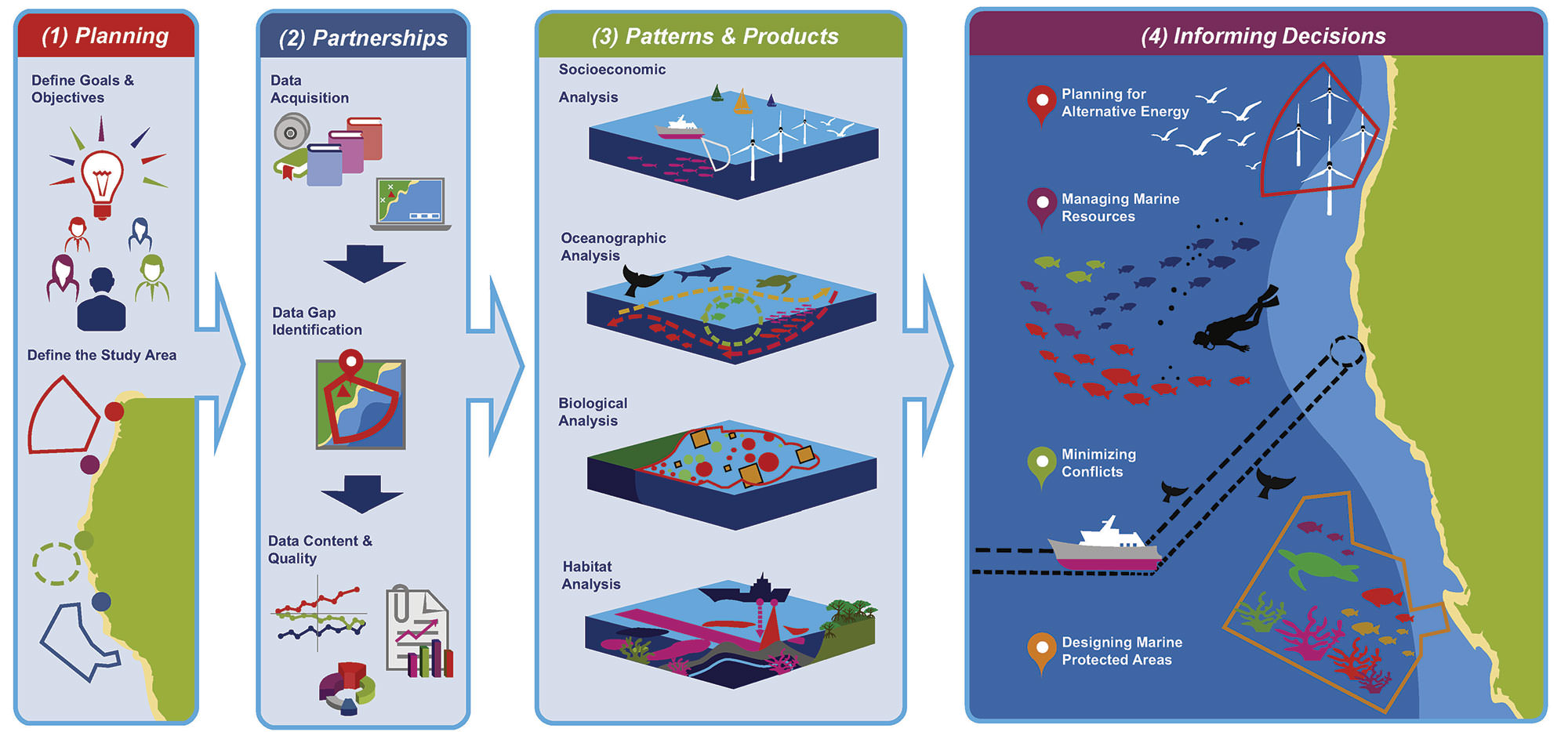
I had the chance to talk with the two primary scientists working on this project in Hawaii, Bryan Costa and Dr. Matt Kendall from the National Centers for Coastal Ocean Science. We began the discussion by talking a bit about NOAA's role in Offshore Wind Energy projects and how they became involved in the support for this effort. Bryan was the first to explain:
BRYAN COSTA: NOAA's work in offshore wind, particularly NOS, or the National Ocean Service…it's been pretty diverse over the years since 2011. Its included things like conducting surveys of what local residents feel about offshore wind, [and] how they use the ocean. It's also included work such as mapping the seafloor habitats, and characterizing those habitats, and also predicting where certain animals might be in the ocean. These products were designed to inform the leasing process…including siting, anchor placement, cable routing, construction and operation.
HOST: Matt had a great way to further explain the process to me.
MATT KENDALL: So you've got a few main players in siting offshore wind development… you've got a municipality that needs power, you've got an industry that can place offshore wind turbines and get power, and then you've got an agency that regulates and leases the seafloor for where those things [turbines] can get placed…and that is BOEM, the Bureau of Ocean Energy Management. They're the main regulatory agency in this. NOAA's role is providing them information to help make decisions about where to place things so that they don't impact the environmental issues that Bryan was talking about – they don't impact seabird flyaways, deep corals for where things are going to be anchored, or some communities where they are going to have to pass the power line from offshore up into the municipality where it gets hooked up…
HOST: Next we talked about some of the greatest benefits of Wind Energy in Hawaii, and why is this a good fit for NOAA support.
MATT KENDALL: Hawaii is really a perfect fit for getting power from a couple of different things. Anybody that has been there knows that they have an abundance of sunshine – and driving around you see a lot of solar panels on roofs. Anybody that's been to the beach knows there is always a nice breeze – and they have an abundant natural resource there that can be harnessed to get a lot of their power. In fact, the state of Hawaii has set a goal of achieving 100% of their energy need [supplied by] renewable sources by the year 2040.
BRYAN COSTA: The state of Hawaii stands to benefit in several ways from offshore wind. First – the state's energy prices are the highest in the Nation, and they are so high because over half of the state's electricity is generated from imported oil. Generating more electricity from local sources, like wind, really could help reduce the cost of electricity in Hawaii. Also, it has the potential to reduce emissions that are harmful to human health, as well as to create jobs in a new business sector, and to help the state of Hawaii rely less on foreign energy sources and to achieve greater energy independence. That said, wind energy is a pretty new industry in the U.S. – its more developed in Europe, in particular – so there are potential impacts and trade-offs and it will require further analysis as the wind energy releasing process unfolds in Hawaii and in the U.S. at large.
HOST: I asked Bryan and Matt to walk me through the steps of a biogeographic assessment.
BRYAN COSTA: The biological assessment, or what we call the biogeographic assessment, typically has four main steps. The first step focuses on planning, and in that step a partner will reach out to us with an informational need, and we will meet with them to determine their priorities and what type of data will be most useful to meet their requirements. So, for example in Hawaii, BOEM reached out to us because they were expecting to receive a lease request for renewable energy from independent companies and they needed help compiling information about the marine resources around the main Hawaiian Islands. The second step in this framework is really focused on partnerships, and during this step what we usually do is meet with local experts, "data providers", and we work with them to inventory existing spatial information, and to begin to identify data gaps. It's really critical for us to work closely with these partners because they're the ones who collected the data and understand it best. In Hawaii we worked with many different organizations – too many to name during this podcast – but there are four in particular that we worked most closely with: NOAA's Southwest Fisheries Science Center, NOAA's Pacific Island Fisheries Science Center, the State of Hawaii and also the University of Hawaii. The third step in this process focuses on patterns and products, and during this step we analyze and combine the data sets that we gathered from the partners and we use it to characterize broad spatial patterns in the marine environment. We develop products – things like technical reports, webmaps, and spatial data sets – and we make sure that they are useful, meaningful and accurate for all of those folks involved. Then the fourth and final step really focuses on informing decisions, and during this step we work with a partner agency to help them answer questions using those products specific to their needs. In Hawaii this is an ongoing process – our project was a small piece of a much larger and longer leasing process being conducted by BOEM in collaboration with the state of Hawaii.
MATT KENDALL: Yeah – if I could just add a little bit to that…my title is a Marine Biologist and Bryan's is a Marine Ecologist, which makes you think we get to do cool things out in the ocean. The fact is, a lot of this kind of work is done from your desk and the internet and on the phone. There's a huge body of information that has already been collected and what really needs to be done is that it just needs to be re-packaged in a way that makes it the most useful for BOEM and energy planners to make decisions with. That's really a big part of what our role is in this -gathering and interpreting relevant information to make it useful in a new context. It's really step three in about a twenty step process that BOEM and the state and others are engaged in, so it doesn't replace that survey-level of information that needs to be collected. When they do narrow choices down to a particular spot, there will be additional field data that's collected to further understand and refine the potential options for placing these things, but we're just not at that step yet.
HOST: To the everyday ear, this project sounds like a lot of numbers. I wanted to know what people did with the data collected.
BRYAN COSTA: The data goes to a few different places at the end of a project like this. Specifically it is sent to our partner agency – in this case the work in Hawaii was funded by BOEM's Pacific Outer Continental Shelf Region – to conduct their own analyses. It's also ingested into an online map so that folks can view this information dynamically on their own. Lastly, it's also archived at NOAA's NCEI, or the National Centers for Environmental Information, and what NCEI does is preserve it and also make it freely available to the public online. Usually we make the data available in a few different ways – so that we can make is accessible and understandable to as many folks as possible – and these different mediums also give us the opportunity to explain what we did in different ways to different people, and ultimately why this work is important to a larger audience. It provides a foundation to help maintain productive oceans that support the economy of the United States.
MATT KENDALL: Yeah, and just to answer the question "what do we do with the data?" in a different way: NOAA's role stops short at interpreting and providing specific recommendations. BOEM has subject matter experts in seabird ecology, in coral reefs, in marine mammals and sea turtles. It's their role to take the information that we provide and make the decisions regarding placement or construction timeframes of when they might put an offshore development in.
HOST: Like many NOAA projects, partnerships were essential to this project- Bryan and Matt explained why.
BRYAN COSTA: Our partners were critical to the success of this work and to other types of work like this, and what these partners did was provide us with data sets describing the distribution of marine resources. They also lent us their time and expertise to help us understand those data sets, to review our draft products and analyses, and to make sure that what we were producing was meaningful, accurate and useful. In some cases the partnerships that we forged during this work have continued, resulting in additional projects that are still going on today.
MATT KENDALL: We do most of the heavy lifting in terms of the analyses, but in some cases its better and more appropriate to actually outsource that to some of our partners, and the reef fish section of the [project] report is a good example of that. We actually worked with the scientists at the University of Hawaii to do the analytical portion of that work and then fold it in to the larger report. But in all cases, they're providing data, they're explaining caveats about appropriate uses, they're assisting with the interpretation, they're reviewing the data products that we're providing, and in many cases they are co-authors in the report.
HOST: I was curious to learn what they felt were the next steps for NOAA in terms of Offshore Wind Energy.
BRYAN COSTA: I'll be interested to hear Matt's answer (laughing)…but in my opinion the next step for NOAA is to continue cultivating the many partnerships we've developed since 2011 – since then we've entered into agreements with many federal, state and regional partners, and we've engaged in over ten or so projects in Alaska, the west coast [of the U.S.], the Pacific Islands, Gulf of Mexico and the Atlantic coasts directly related to ocean energy. There is definitely a lot of work to do as this industry continues to grow, and NOAA and NOS in particular, has the technical experience and the unique technical capacity to help stakeholders make more informed decisions about their marine resources moving forward.
MATT KENDALL: Another important thing for NOAA to do looking to the future is to maintain long term data sets on a lot of the flora and fauna that are involved. It's a question of, "where are the seabirds today? Where are the marine mammal migration corridors today?" and one of the important things that NOAA can continue to do into the future is to maintain a lot of these long term data sets. Understanding the impacts of offshore wind development into the future relies on knowing where things are now – but that doesn't mean you can stop collecting the data once you've made the decision [where to place the turbine]. Understanding the long term impact [requires] maintaining those data streams so that you can look at how the organisms respond or their distribution changes in relation to any decision or placement of infrastructure that's made.
HOST: Both Bryan and Matt have had the opportunity to research and participate in a wide variety of projects during their careers, covering such diverse topics as coral reefs, sanctuaries, habitat conservation, fish habitats, benthic mapping…just to name a few. I wanted to know what each of them took away from this particular project experience.
BRYAN COSTA: I think that Matt and I were chosen for this project for a couple reasons: first, we have history in the area – he and I have been working in Hawaii, and in Matt's case in the broader Pacific, for a number of years and have had a lot of connections and a lot of opportunities to meet people there. That really helped jump start this project because those partnership were so critical to the success of the work.
MATT KENDALL: I'm excited to see how the products will be used over the coming years to not only help decide how best to develop offshore wind in Hawaii but also help with some of the other important environmental decisions that are on the horizon for Hawaii.
HOST: That's it for this episode of the NOAA Ocean Podcast. Thanks to Bryan Costa and Dr. Matt Kendall for educating us on marine biogeographic assessments and how they support Offshore Wind Energy development. To learn more about this project, or any ocean-related topic, visit our website at oceanservice.noaa.gov. We appreciate you taking the time to learn with us, and hope you'll join us again soon. Until then…thanks for listening.

From corals to coastal science, connect with ocean experts to explore questions about the ocean environment.
Subscribe to Feed | Subscribe in iTunes
Browse All Episodes of the NOAA Ocean podcast