Shipwreck Detective
Ocean Shorts: Episode 15

The Latest Discovery
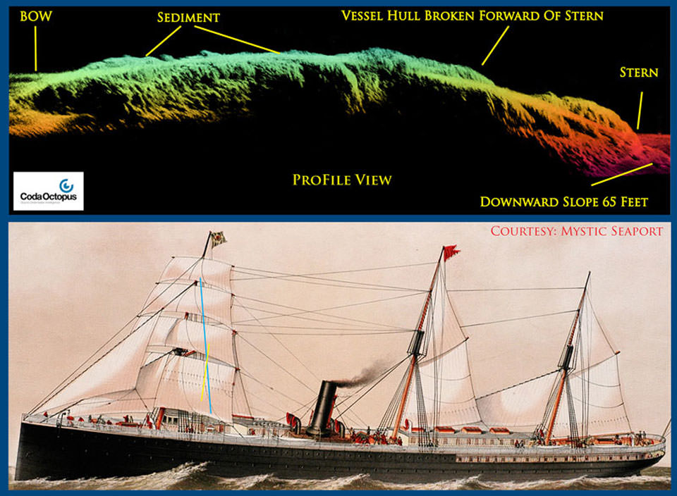
In November 2014, a joint archaeological expedition led by the Office of National Marine Sanctuaries Maritime Heritage Program brought back the first-ever 3-D images of the City of Rio de Janeiro, considered by many historians as the "Titanic of the Golden Gate." Listen in to this conversation with NOAA's Robert Schwemmer, co-leader of a two-year study to locate and document shipwrecks in California's Gulf of the Farallones National Marine Sanctuary and the surrounding area.
Transcript
This is Ocean Shorts from NOAA's National Ocean Service. In this episode, we look back at a November 2014 archaeological expedition led by the Office of National Marine Sanctuaries Maritime Heritage Program. This mission brought back the first-ever 3-D images of the City of Rio de Janeiro, considered by many historians as the "Titanic of the Golden Gate." Listen in to this conversation with NOAA's Robert Schwemmer, co-leader of a two-year study to locate and document shipwrecks in California's Gulf of the Farallones National Marine Sanctuary and the surrounding area.
HOST: How many wrecks are we talking about in the greater Gulf of the Farallones?
ROBERT SCHWEMMER: If you were to include the Gulf of the Farallones National Marine Sanctuary, nearly 1,300 square miles by itself; the northern Monterey Bay National Marine Sanctuary from San Mateo County north, which is also managed by the Gulf of the Farallones National Marine Sanctuary — another 1,400 square miles. Then you include the Golden Gate Recreational Area up to the Golden Gate Entrance or bridge, as most people know it today, there are over 300 ship and aircraft losses.
HOST: I'm guessing that two years isn't enough time to locate and document all of the wrecks in this region.
ROBERT SCHWEMMER: In two years you will not find even a quarter of the shipwrecks that are out there, because finding a shipwreck is of course first and foremost confirming what the shipwreck is. The next phase is mapping, it's documentation, sonar imagery, it's doing the map, and it's doing additional research on the historical significance of that wreck. All of this plays into building the nomination in the National Register of Historic Places, so it's quite a lengthy process. And so we may go back with different instrumentation to look at wreck sites to get different types of documentation. We found the shipwreck Selja — turn of the century, went down off Point Reyes — very difficult to record with an ROV because of the strong currents and the lower visibility. It would be an ideal shipwreck to take a multibeam or 3D sonar image and basically paint the wreck in color. We'd have a better understanding of how the ship lies. It's pretty catastrophic site, looking at it, the way it's twisted on the bottom. So it's a project that would be ongoing. So we have to determine, in the second year, do we return to the sites that we have discovered and continue additional survey work, or do we move on and try to discover new sites. So that's all part of the research plan, pre-mission, to prioritize it. It has a lot to do with sea state and weather conditions.
HOST: You mentioned the National Register of Historic Places. Is the goal to get all the shipwrecks you find included in this national register? Why is this important?
ROBERT SCHWEMMER: Listing a shipwreck on the National Register doesn't necessarily give it a higher level of protection, but it gives it the level of recognition of historical significance with the American public and it also allows for funding opportunities and grants. The National Historic Preservation Act directs government agencies like NOAA that manage federal lands, including submerged lands, to inventory prehistoric and historic heritage resources. And upon discovery, we map, we photograph, the documentation, we develop outreach and educational initiatives based on those resources … which can include museum exhibits at our learning centers, but most importantly, if the resources meet the criteria for the National Register of Historic Places, then we process the nomination for listing, which we have done a couple of times out here in the Pacific. So that's the really important mandate requirement to go out and record these sites. The educational value and touching people with these stories is a bonus.
HOST: So what's coming up next? Are you planning to continue work in the Golden Gate area?
ROBERT SCHWEMMER: Our goal is actually to return to the work we did in November with the discovery of the Rio de Janeiroas as well as sonar imaging of the City of Chester — that's all part of this, because even though we're working outside the boundary of the Gulf of the Farallones National Marine Sanctuary or the northern boundary of the Monterey Bay National Marine Sanctuary, it's still a part of the maritime cultural heritage landscape. You know, they cross both lines. They all interconnect, these stories. A matter of fact, just within the Golden Gate entrance there, we have three vessels built by John Roach and Son in Chester, Pennsylvania: we have the City of Chester, we have the City of Rio de Janeiro, and we have the City of New York. All lost right there at the mouth of the Golden Gate.
You can find the link to hear the rest of this great interview on our website at oceanservice.noaa.gov/podcast … thanks for listening.
