The nautical chart has served as a guide to navigating the seas for the past 400 years. While the function of the nautical chart has not changed over the centuries, 21st-century methods for creating and updating charts have dramatically improved. Added to this, today's hydrographic data collected by modern-day ships is used for many purposes in addition to updating nautical charts.
Then...
Following the establishment of the Survey of the Coast by Thomas Jefferson in 1807, sea floor depth measurements were collected using handheld lead line surveys and, later, single-beam echo sounders. Both of these methods sampled and collected depth measurements for only a small percentage of the ocean bottom.
And Now...
Today, NOAA hydrographic ships are equipped with sophisticated multibeam echo sounders that survey large swaths of the ocean floor, collecting a tremendous volume of bathymetry (or depth) data. Multibeam technology can also collect water column and acoustic backscatter data. Water column information identifies targets between the surface and the seabed (such as fish). Acoustic backscatter data indicates the composition of the seabed. Once this extra water column and backscatter information is processed and combined with bathymetry, it can be used to indicate what types of habitats exist on and near the sea floor. Marine scientists use this information to aid in ecosystem planning and protection. Following are some examples of how multibeam sonar is used.
Mapping nearshore habitats while updating nautical charts.
In 2017, NOAA Ship Rainier surveyed the nearshore areas of NOAA’s Channel Islands National Marine Sanctuary as part of the Southern California Seafloor Mapping Initiative. Up until 2017, about 25 percent of the sanctuary remained uncharted with modern technology (nearshore areas of the sanctuary were last surveyed using lead-line techniques in the 1930s). The ship used new multibeam echo sounders to collect bathymetry data to update nautical charts as well as generate backscatter imagery, which the sanctuary uses for habitat mapping. Today's technology helps improve nautical charts and navigation safety while also providing critical habitat data that the sanctuary needs to manage its resources.
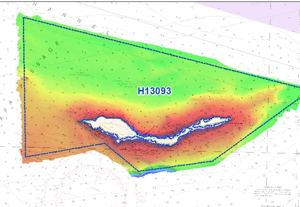
Bathymetry data collected near California's Anacapa Island by NOAA Ship Rainier.
Mapping fault lines and mud volcanoes while updating nautical charts.
In 2017, NOAA Ship Fairweather surveyed a portion of the Queen Charlotte-Fairweather fault system on the U.S.-Canadian border. The ship surveyed an area west of the Dixon Entrance, a Pacific strait located between Alaska and British Columbia. The survey, done at the request of the U.S. Geological Survey and California State University, supported earthquake, tsunami, and storm surge readiness for coastal communities in the region. The Fairweather characterized both the sea floor and the water column using its mulitbeam echo sounder. The detailed images show the main fault line as well as a mud volcano and associated gases emitting from the sea floor.
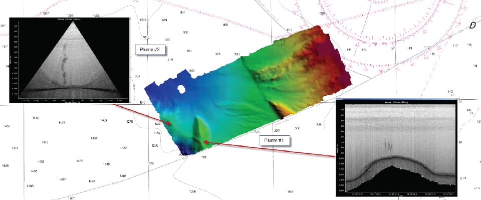
Side scan sonar images of the Dixon Entrance mud volcano and associated plume of gases with location shown on a map generated from multibeam echo sounder bathymetric data.
Mapping essential fish habitat while updating nautical charts.
In 2016, NOAA’s Office of Coast Survey and the National Centers for Coastal Ocean Science (NCCOS) collaborated to map the continental shelf near Wilmington, North Carolina, for navigation safety and habitat analysis to support ecosystem management and ocean planning. Past habitat surveys conducted by NCCOS were refined for charting. Scientists from Coast Survey, NCCOS, and the University of New Hampshire’s Center for Coastal and Ocean Mapping/Joint Hydrographic Center (UNH CCOM/JHC) refined best practices for the multi-objective mission. The researchers tested a bottom camera attached to a grab sampler prototype developed by UNH CCOM/JHC scientists. Bottom photos, sediment samples, backscatter, and bathymetry were collected to meet both habitat analysis and charting needs. The project opened discussions on how scientists can best collect data that meets multiple needs, and how sea-floor imagery can best be served to stakeholders.
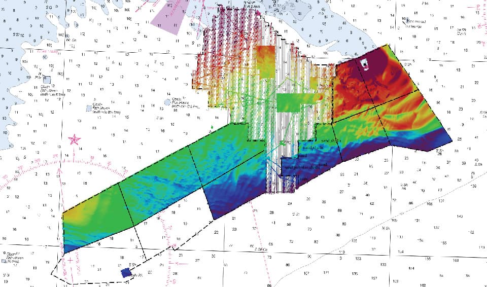
Integrated image of bathymetric and backscatter data of approaches to Wilmington, North Carolina. Of the 900 square nautical miles that the chart updated. 570 square nautical miles will yield new habitat data.
Mapping offshore canyon habitats while updating nautical charts.
In 2016, NOAA Ship Rainier surveyed the offshore areas of Olympic Coast National Marine Sanctuary as part of a project to better understand the bathymetry and habitats of Washington’s submarine canyons. The ship’s multibeam echo sounders collected swath bathymetry to update nautical charts while also collecting acoustic backscatter and water column data in support of coastal management efforts.

Backscatter data collected by NOAA Ship Rainier in 2016-2017 in Olympic Coast National Marine Sanctuary.
Read More
Did you know?
While NOAA's mission to survey the sea floor and update nautical charts has remained basically the same for centuries, the data NOAA hydrographic ships collect today is used for many purposes beyond hydrography. It's part of NOAA’s integrated ocean and coastal mapping process—an area is mapped once using high-tech multibeam sonar and other tools, and the collected data is used many times by researchers and scientists from various fields.

Get Social
Last updated: 06/16/24
Author: NOAA
How to cite this article