Precision Navigation
Meet the next generation of integrated marine navigation services, tailored for our nation's busiest waterways.

Safer Transport in the Nation's Largest Port
The port of Long Beach is the largest port complex in the nation and the ninth busiest port worldwide. NOAA products and services supporting the Port of Long Beach precision navigation project are expected to save vessels an estimated $10 million per year in lightering costs. Additionally, for every extra foot of draft allowed by the port, tank vessels can load $2 million of extra product. The port's precision navigation project integrates private sector innovation and NOAA data streams to support the increasingly complex decisions mariners must make as they navigate ever-larger ships through U.S. ports. Credit: U.S. Department of Homeland Security.
NOAA's precision navigation project is an effort that brings together private-sector innovation and NOAA data streams to foster safer navigation in our nation's largest and busiest seaports. Precision navigation is about helping mariners make increasingly complex decisions as ever-larger ships make their way through congested U.S. ports while dealing with changing ocean conditions.
Case Study: Port of Long Beach
The port of Long Beach in California is the first seaport to adopt precision navigation. This port was an ideal candidate for this project for several reasons. First, it's the largest port in the country and ninth busiest port in the world. Second, the port is exposed to the open ocean and is influenced by unique wave, swell, and water-level conditions that make navigation challenging. And third, ultra-large crude carriers entering Long Beach were vulnerable to potential groundings when waves arrived in long period swells.
With the completion of the precision navigation project in 2017, navigation within the port was not only safer, but authorities were able to increase the draft for incoming ships from 65 feet to their goal of 69 feet. Each additional foot of draft allows carriage of 40,000 additional barrels of crude oil, and the reduced need for lightering saves shippers an estimated $10 million per year.
These benefits were made possible, in part, by the expansion of the physical observing infrastructure at the port, including forecasts for wave and swell conditions from the National Weather Service, water level data from the Center for Operational Oceanographic Products and Services, wave buoy data from the U.S. Integrated Ocean Observing System, shoreline data from the National Geodetic Survey, and high resolution bathymetry from the Office of Coast Survey.
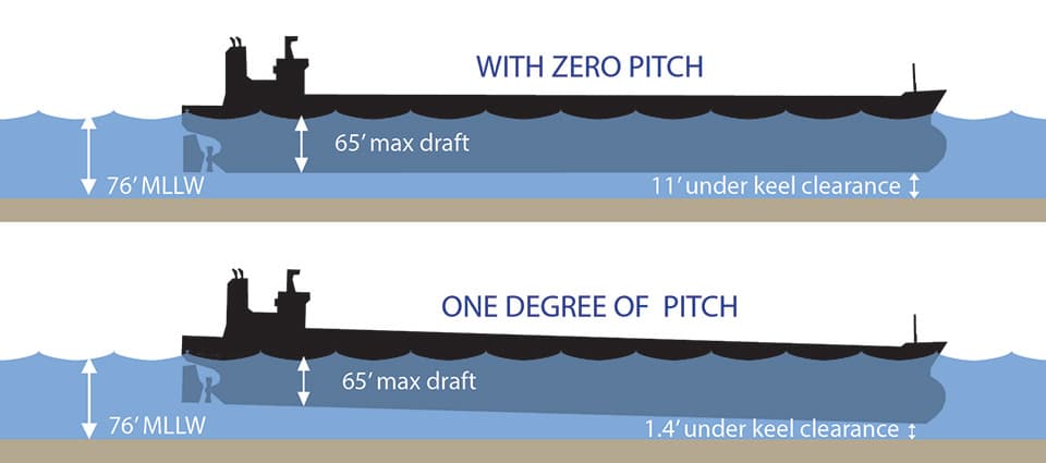
The Long Beach precision navigation project shows how NOAA supports the increasingly complex decisions mariners make as they navigate ever-larger ships through U.S. ports, especially decisions related to under-keel clearance (the distance between a ship's keel and the sea floor).

Pitch Perfect
You wouldn't think that a ship pitching downward by one degree would make much of a difference, but consider this: An 1,100-foot ship that pitches one degree can result in its draft (the amount of the hull that is below the water) increasing by over ten feet. With the completion of the port's precision navigation project in 2017, navigation within the port is now not only safer, but authorities have increased the draft for incoming ships from 65 feet to 69 feet.
Current Projects for Precision Navigation
NOAA is currently conducting precision navigation projects in the ports of the Lower Mississippi River and New York/New Jersey.
- The Lower Mississippi River port complex is the largest port cluster in the United States. These five ports provide a gateway to Latin America, Northern Europe, and the Mediterranean. These ports also provide critical access to the inland waterway system and intermodal connections to rail and highway.
- The ports of New York/New Jersey encompass the area from the sea buoy up the Hudson River to Troy, New York. It is the largest port on the East Coast, and the third-largest in the nation. A single collision or grounding along these waterways could halt the activity of a significant portion of the multibillion dollar shipping industry, with additional harm to other industries upstream that depend on it.
Precision navigation can address the unique challenges of these ports, which include strong currents, constrained spaces, wave dominated approaches, low under-keel clearances, and frequent fog.
Did you know?
What's an inch of water worth? Our nation’s ports are the lifelines of our economy. In 2016, foreign trades through U.S. ports were valued at $1.5 trillion—$475 billion exports and $1.0 trillion imports were moved by vessels. When goods travel through ports, it means they are traveling via ship.
