Tides and Water Levels
How are Tides Measured? - The New System
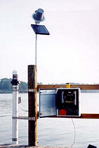
Advances in technology have helped solve many of the problems associated with the old tidal recording systems. Microprocessor-based technologies allow for customized data collection and have improved measurement accuracy. While older tidal measuring stations used mechanical floats and recorders, a new generation of monitoring stations uses advanced acoustics and electronics. Today's recorders send an audio signal down a half-inch-wide sounding tube and measure the time it takes for the reflected signal to travel back from the water's surface. The sounding tube is mounted inside a 6-inch diameter protective well, which is similar to the old stilling well.
In addition to measuring tidal heights more accurately, the new system also records 11 different oceanographic and meteorological parameters. These include wind speed and direction, water current speed and direction, air and water temperature, and barometric pressure.
Like the old recorders, the new measuring stations collect data every six minutes. However, whereas the old recording stations used mechanical timers to tell them when to take a reading, timing is controlled on the new stations by a Geostationary Operational Environmental Satellite (GOES). The stations also use these satellites to transmit their data hourly to NOAA headquarters. In the event of a storm, the stations can be programmed to transmit their data every six minutes. Field teams can quickly check and maintain the systems using laptop computers. In addition, all of the raw and processed data are available over the Internet.
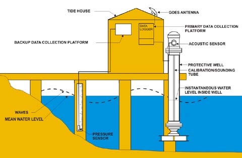
While similar in design to older tide houses, these newer enclosures are designed to protect sensitive electronics, transmitting equipment, and backup power and data storage devices. The older stilling well has been replaced with an acoustic sounding tube and the tidal staff with a pressure sensor. The new field equipment is designed to operate with the highest level of accuracy with a minimum of maintenance, transmitting data directly back to NOAA headquarters for analysis and distribution.
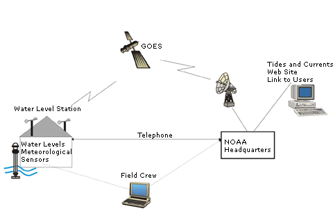
The earliest tidal monitoring stations were small and self-contained, but they required frequent visits for maintenance and adjustment. Today, stations are still self contained but are very accurate, require little maintenance, and are part of a larger nationwide network. Today, data are transmitted to NOAA headquarters via satellite shortly after they are collected. After rapid computer analysis, the data are immediately posted to one of several Web sites where they can be universally accessed. With these systems in place, scientists can run diagnostic checks on the equipment without needing to travel into the field. This saves both time and money.