Meteotsunamis
NOAA Ocean Podcast: Episode 70
Meteotsunamis are a series of large waves fueled by area-pressure disturbances like storms, and can occur in many places around the world, including the Great Lakes. In this episode, we revisit our interview with Dr. Gregory Dusek, senior scientist with NOAA’s National Ocean Service and discuss his research on these waves.
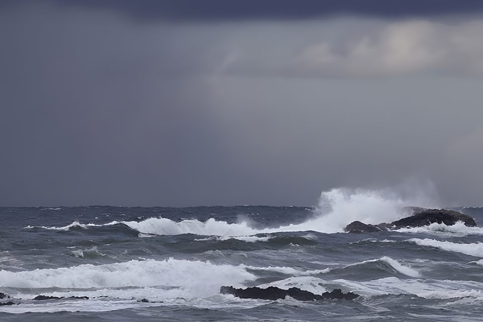
Meteotsunamis can reach heights of 6 feet or more. These waves can be fueled by storms, and are typically much smaller and less destructive than those associated with seismically generated tsunamis.
Listen here:
Or listen in your favorite podcast player:


Transcript
HOST: In this episode of the NOAA Ocean podcast, we revisit an interview on meteotsunamis: large waves that are fueled by air-pressure disturbances like thunderstorms. Let’s dive into the research with Greg Dusek, senior scientist with NOAA’s National Ocean Service. And don’t forget to check out our show notes with a link to the full episode.
HOST: Let’s start with a definition of a meteotsunami.
Dr. Gregory Dusek, senior scientist, NOAA’s National Ocean Service
DUSEK: They’re just what they sound like: meteorologically-driven tsunami waves. So in other words, instead of tsunamis driven by an earthquake or an underwater landslide, they’re driven by the weather. And specifically, typically fast-moving storm systems, which tend to cause a wave on the ocean surface, and that wave in some cases can reach several meters in height. So their similarities with seismic tsunamis, or the more traditional tsunamis, are that the waves are similar. In other words, they’re not like the waves you see at the beach, which might be 10 seconds long. These tend be anywhere from a couple minutes to two hours long. So they’re relatively long duration rises and falls of water level.
HOST: So the waves are similar to tsunami waves, but how do meteotsunamis differ from what you called traditional tsunamis.
DUSEK: I think when a lot of people hear the word tsunami, they immediately think to like the Japanese tsunami that occurred a number of years ago where, you know, it was just a devastating impact. And really, those seismic tsunamis are oceanic, global events. They impact, in some cases, across the entire globe. With meteotsunamis, there’s just not that same amount of energy in the wave. So often they might affect just one harbor, or one estuary. So they can be very localized. And they also tend to not be as large, because you don’t have that same amount of energy in the ocean. So it’s really those more rare and unique events which might occur again once a year or maybe less frequently that we’re interested in, in terms of a potential hazard.
HOST: How much did we know about meteotsunamis before you did your new study?
DUSEK: We’ve known a little bit about meteotsunamis I’d say over the past 20 years or so. Even as early as 1954, there was a documented event of a meteotsunami in the Great Lakes and it was reportedly on the order of ten feet high, and actually ended up causing seven deaths near Chicago. And there have been some other recent examples on the East Coast of the U.S., one in Daytona Beach in 1992, it was right around July 4th, and there was a wave people said was about ten feet high, and apparently damaged over a hundred vehicles and caused 75 or more injuries to people on the beach.
HOST: And what did you discover in your study?
DUSEK: So we found on the order of about 25 meteotsunamis a year occur along the U.S. East Coast, which I think going into this I would have thought to see maybe a handful each year. So we were surprised to see that they occur quite frequently. I think the important caveat is the vast majority of those are small. So 90 percent of the events we found were under about a foot and a half. So things that probably aren’t going to cause much of a problem. When you look at potentially hazardous events, those were probably, say, two feet or more. Those might happen once a year or so. So events that might cause damage or injury are a little less frequent. But still, about every year or so you could have one of those types of events.
HOST: So are these events distributed along the U.S. East Coast, or do some regions see meteotsunami events more often?
DUSEK: Certain locations along the East Coast tend to see events more than others. In particular, along the Carolinas, tended to see the most events on the order of seven or eight per year in some cases. And part of that is just the location of our instrumentation. Some of our gauges might be more protected and might not observe events as easily. On the North Carolina coast, most of our gauges are out on piers and things like that and so they are more apt to see events that occur in the open ocean. But then also, a lot of what determines where we see these are where weather systems are propagating. And it just happens to be that North Carolina is exposed to summertime thunderstorms, which can drive events. Wintertime storms, like Nor’easters, which can drive events. And then tropical storms. So all the different storm forcings readily occur along the Carolina coast, which is one of the reasons we think we see them there more often than in other places.
HOST: But we’re mostly worried about those events that cause waves over a couple of feet, right?
DUSEK: Yeah, that’s right. So what we propose is that events over about two feet is where you start worrying about potential impacts. So that might be, in the summertime, people on or around the water could be impacted, which we’ve seen in past events. And during wintertime, during a winter storm, or during a tropical storm, where people aren’t really out at the beach, then the impact starts becoming: do we see additional flooding caused by these events, do we see additional erosion caused by these events. So it’s more of a contributing factor to bad weather in large ocean events that are already occurring.
HOST: That’s a wrap! Check out our show notes for the full episode and subscribe to us in your favorite podcast player.

From corals to coastal science, connect with ocean experts to explore questions about the ocean environment.
Social