After a Hurricane Hits: NOAA’s Emergency Response Aerial Imagery
NOAA Ocean Podcast: Episode 30
Since the early 1900’s the National Geodetic Survey has been taking photographs from airplanes to capture the Earth below. Podcast host Megan Forbes talks with two NOAA experts about their role in emergency response imagery collection after hurricanes, and what it provides for the public.
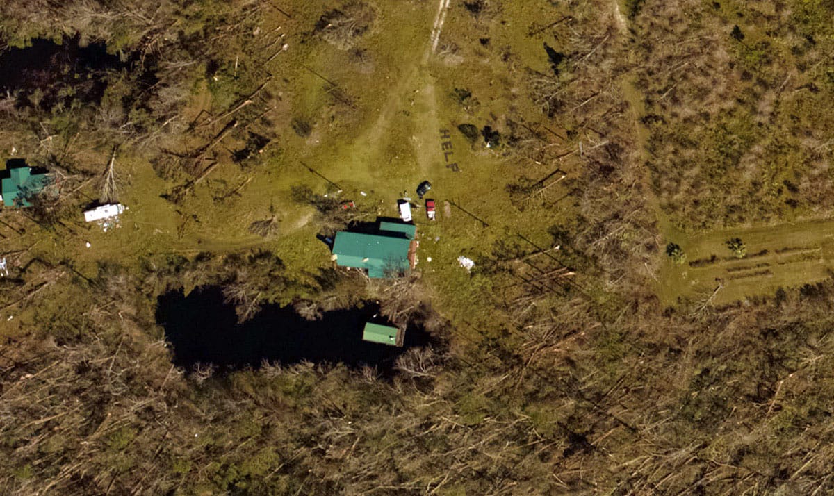
NOAA aerial imagery from Youngstown, Florida, showing a “help” sign made out of trees. A Florida family awaiting assistance after Hurricane Michael was discovered after the sign was photographed by a National Geodetic Survey aerial team and then viewed by a family member.
Transcript
HOST: You’re listening to the NOAA Ocean Podcast! I’m Megan Forbes... and today, I’m thinking about how we at NOAA monitor the 95,000 miles of coastline in the U.S. What better way than from a bird’s eye view? Since the early 1900’s the National Geodetic Survey has been doing just that - taking photographs from airplanes to capture the Earth below. These photos are captured while flying at 10,000 feet over the ground and can cover approximately two square miles of the Earth’s surface with each shot.
Today, the capture of photographs is controlled by Global Positioning System, better known as GPS, and the photos are used to define the national shoreline, create maps and charts, monitor environmental change, and provide damage assessment in response to manmade or natural disasters.
One of the more frequent types of natural disasters we have here on the east coast comes in the form of a hurricane. So...what do hurricanes and aerial photography have in common? Well, my two colleagues and I are about to uncover that for you.
I have here in the studio with me Lieutenant Daniel Helmricks, a Remote Sensing Technology Specialist with the National Geodetic Survey, and we are joined from Charleston by Maryellen Sault, a cartographer, also with the National Geodetic Survey at NOAA.
So Dan...what happens in the hours after a hurricane hits a particular part of the coast?
DANIEL HELMRICKS: In the hours after, we get from FEMA an area that they want to have surveyed, or we have our own requirements that we need to map the shoreline.
HOST: Okay, you are one of the people that actually goes up into the airplane itself, is that correct?
DANIEL HELMRICKS: Yes, that’s correct. So the aircraft that we use is the King Air Beechcraft 350, the crew - it’s just myself and two pilots. So the pilots are the ones up flying, and I’m the one in the back operating the cameras - making sure it’s firing.
HOST: So you have to know a lot about flight and have an idea of where you are…
DANIEL HELMRICKS: You’ll see your position on the screen, but you have to be able to gauge the...looking out the window, seeing what you see, [if] there’s damage below you...starting the camera as soon as you can. If there’s no damage or nothing to take photos of below you, if it’s just open water, we don’t want to take photos of that stuff because its just more data that we have to push over the internet to get back.
HOST: and that’s where some of the GPS comes in...its helping you determine where you are located, etc.?
DANIEL HELMRICKS: The IMU collects the GPS data, it’s part of the data set that we then process later, so we can tell exactly where each image was taken...stabilize the image, even if the aircraft is at somewhat of a bank angle and turning, we can position that photo correctly onto the map so you can see exactly where that damage is. The turnaround on getting the imagery out is about 6 hours from the time the wheels touch down on the ground to the time the imagery is back up online for people to look at. As soon as the wheels touch down, we’re pushing that data already back to some of the people who are in the office who are processing it.
HOST: As a cartographer, Maryellen, this data is coming your way...so when you know that a hurricane has happened...in the hours after it hits, what happens for you?
MARYELLEN SAULT: My role is to respond to the ‘Contact Us’ email address that’s on the Emergency Response Imagery Viewer website. The questions that we receive cover everything from the general, “When are you going to fly in my area?” to a little more technical questions. I often tell folks, when I am out and about, that all of the emails that are sent to that “Contact Us” address are read and responded to in a timely manner.
HOST: Do you happen to talk to, or have connection with, the folks up in the airplane...if somebody says to you ‘I think this area has been really damaged’...are you coordinating back to them, saying “you should go here”?, or have they often already covered it?
MARYELLEN SAULT: I don’t talk to the pilots directly, but I do have the capability to get areas where imagery is needed to them. Take Hurricane Irma, for example, there was a small subdivision that was missed from the imagery that was acquired...I had received multiple emails from folks letting me know that their area had been missed, and they were very anxious to see how their homes had fared after the storm. I funneled that request up the chain of command where it made it to the pilots, and fortunately the plane was still in that area, and was able to get the imagery the next day. I then reached back out to those folks from that subdivision and alerted them that we did acquire the imagery, and they were very appreciative of the effort that we went through to get their data for them.
HOST: That’s really cool...so you’re kind of a conduit between the public and NOAA! That’s great.
HOST: Dan, I’ll go back to you - how did you become involved in this Emergency Response Imagery collection?
DANIEL HELMRICKS: Being an officer, my assignment changes every two and a half to three years…
HOST: And you’re an office with the NOAA Corps…
DANIEL HELMRICKS: With NOAA Corps, yes. And so Emergency Response Operations just happened to fall under the scope of work that the assignment I am currently in deals with. I kind of knew, coming into it, what it all entailed. The aspect of being able to fly and see the country, photograph the shoreline for the purpose of updating charts is one of the things that fascinates me. Adding in this aspect of doing emergency response...it's been a different way to see the country, and see how the country is before a hurricane...what it’s like during a hurricane...and then how the country or the communities have rebuilt after the hurricane. Many of these areas, they get hit every year or every couple of years…
HOST: Every year you have the past to compare to...that is fascinating! I don’t think I’ve ever thought about that aspect of it.
How about you, Maryellen…’cartographer’ can mean a lot of things. How did you get involved in emergency response?
MARYELLEN SAULT: I’ve been involved since 2003 after Hurricane Isabel, and since that time I’ve had multiple roles, but the most recent role has been interacting with the public through the ‘Contact Us’ emails, and then actually using the imagery to look for significant shoreline changes in the impacted coastal areas. Nothing is static...the shoreline and port areas are always changing. So, not only am I helping other folks out, but I am actually a user of the imagery myself.
HOST: Dan - we’ll go back to you. How did you become a ‘Remote Sensing Technology Specialist’, and what does that really entail?
DANIEL HELMRICKS: So my background is actually in land surveying, and while going through college, part of the programs I took was remote sensing. From college, I started with NOAA as a survey tech on a hydrographic ship, using sonars to map the ocean floor. So I’ve always been in that field of survey.
HOST: What does it feel like, to know the hurricane’s coming...you’re going to be super busy, you’re going to be on the job...how does it feel to be you? Let’s start with Dan.
DANIEL HELMRICKS: Usually a couple of days leading up...we’re trying to stage somewhere out of the path of the hurricane, but also close enough that we can get in afterwards to get that imagery they next day or even later that day, depending on how quick the hurricane’s moving through. There’s a lot going through your mind…’where are you going to stage? What is going to be your first area to get to?’ Making sure everything is working that way you can hit the ground running. Once the hurricane makes landfall...then it’s more of you’re just kind of on the edge…’how quickly can I get in there? When is this thing going to move off so I can start doing my job in getting that imagery collected and getting it sent off so that people can see what the damage is’... When it comes to collecting the imagery, that’s where emotions go all different directions. When actually looking out the window while collecting the data, that’s where it tears your heart apart, because it is like, ‘yes, I know I’m doing something good in getting this imagery so people can see what happened…’, but just seeing that devastation firsthand, being the first one sometimes to even see any of it because people have evacuated out of areas and there’s nobody there, and just seeing that for the first time...I think that’s the hardest part of this whole job. Seeing that devastation. Once the stress of getting all that and everything is done, I feel real good, because I know that I have helped somebody. Whether it’s just one family knowing that they can look online and see that their house is still there or not there...knowing that I’m helping them get to that point - that’s a big part of it. The response back from people, thanking for the imagery so that they know what they’re going back to, and getting the emails forwarded to us giving appreciation for what we do and what we collect...that’s the biggest thing.
HOST: That’s really amazing.
Maryellen, how about you? How does it feel to be in your job?
MARYELLEN SAULT: It makes me feel...anxious. I know the devastation that these storms can cause, and my heart goes out to all the folks that may be impacted by these storms. I remember looking at the images that were collected after Hurricane Katrina, and just getting extremely emotional. We had a different workflow back then, where the imagery came into the office first - so I was actually one of the first few people seeing all that devastation, and i just remember sitting at my desk with tears streaming down my face. I really want to help folks who are impacted by these storms, and I feel like responding to these emails is one of the best ways that I can do that. I don’t always have the answers to the questions, but I can at least provide other sources of imagery, or try to point them in the right direction, to somebody who could help them. It is always so rewarding when I hear back from folks who let me know how things turned out...I remember a woman who emailed me after Hurricane Irma inquiring about imagery, she was basically just asking when we were going to acquire her area of interest. Apparently her relative did not evacuate, and she was worried about him. I reached back out to her when I saw that her area had been acquired, and she responded back letting me know that they had located the relative, and that he was safe and sound. So...it’s a very rewarding experience.
HOST: That’s awesome. Being able to just reach directly back out to the public in this way is pretty incredible. Thanks to you both for the work that you do!
It’s been a pleasure talking to you...and for those listening, if you have more interest in hurricane imagery or aerial imagery in general, you can check out our website at oceanservice.noaa.gov. Thank you so much to Maryellen and Daniel for joining me today as we talked about the type of imagery that we collect after hurricanes, and what it does for the public. As always, thank you for listening, and we’ll see you again next time.
 An official website of the United States government.
Social