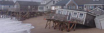
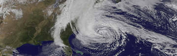
In October 2012, Hurricane Sandy roared toward the mid-Atlantic coast. Even as the hurricane transitioned to a post-tropical cyclone, wind, waves, and storm surge wreaked havoc along the Atlantic Coast, especially to the coasts of New York, New Jersey, and Connecticut.
Preliminary U.S. damage estimates are near $50 billion, making Sandy the second-costliest cyclone to hit the United States since 1900. There were at least 147 direct deaths recorded across the Atlantic basin due to Sandy, with 72 of these fatalities occurring in the mid-Atlantic and northeastern United States.
The communities hit by the massive storm will be rebuilding and recovering for years to come. To aid in this effort, staff from throughout the National Ocean Service are supporting the President's Hurricane Sandy Rebuilding Strategy by delivering coastal science, management, and operational expertise.
Projects & Activities
In response to Sandy, Congress passed a law which provides funding to NOS for mapping, charting, geodesy, modeling, marine debris, preparedness, resiliency, coastal recovery technical assistance, and other activities. Learn about the variety of projects and activities now underway.
View Projects & Activities
Aerial Photography
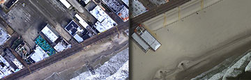
View 'before and after' images captured by NOS's National Geodetic Survey (NGS). In 2012, NGS provided emergency responders and members of the public with a birds-eye view of coastal destruction caused by Sandy. In 2013, NGS also captured images of several areas one year after the storm.
View Aerial Photography
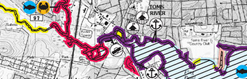
Remapping the Coast
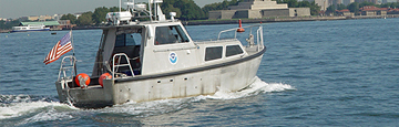
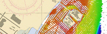
NOAA, the U.S. Geological Survey, and the Army Corps of Engineers are using ships, aircraft, and satellites to measure water depths, look for submerged debris, and record altered shorelines in high priority areas along the East Coast.
View Remapping the Coast
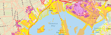
Sea Level Rise Tool
The devastation caused by Sandy is a reminder of the vulnerability of coastal communities to storm and flooding damage. This tool is helping people make better planning decisions that take into account future sea level rise.
View Sea Level Rise Tool
Helping Communities Recover
NOS delivers unique expertise ranging from protecting coastal and estuarine habitat to providing high-accuracy geospatial positioning services. In combination with our decision support, technical assistance, and training activities, NOS is providing a suite of resources and tools to aid recovery.
View Helping Communities Recover
Adapting ESI Maps
NOS is updating existing northeast Environmental Sensitivity Index (ESI) maps to reflect changes caused by Sandy, adding information that enhances the maps' value when another disaster strikes. Historically these maps were used mostly for oil and chemical spills, however they have also proved to be effective tools in preparing for and responding to storms.
View Adapting ESI Maps

Post-Sandy Activity Log
View a log of NOS response activities and operations in the immediate aftermath of Sandy. NOAA's efforts focused on navigation surveys to restore commerce; aerial surveys to aid on-the-ground responders from FEMA and local authorities; and in oil spill cleanup and damage assessment.
View Post-Sandy Activity Log
Hurricane Response: Overview
The National Ocean Service brings a wealth of coastal science, management, and operational expertise to aid communities impacted by hurricanes in their recovery. View a compilation of NOS's roles and responsibilities before, during, and after major tropical storms.
View Hurricane Response: Overview
 An official website of the United States government.
Here's how you know we're official.
An official website of the United States government.
Here's how you know we're official.
