How Currents Affect Our Lives?
Currents Tutorial

Current measurements are important to shipping, commercial fishing, recreational boating, and safety. By using predicted, real-time and short-term forecasted currents, people can safely dock and undock ships, maneuver them in confined waterways and safely navigate through coastal waters. With this information, merchandise and people can arrive on schedule. Lack of this knowledge can lead to collisions and delayed arrivals.
Search-and-rescue personnel can use real-time and predicted current patterns to determine where the water may carry a missing person or floating object(s). Geographic Information Systems (GIS) programs are used to assist in search-and-rescue efforts as well. These programs use the last-known position of the lost person or item(s), predicted and real-time current and weather data, and drift patterns to estimate the location of the person or item(s).
Hazardous material (HAZMAT) cleanup operations also use real-time and predicted current information. Hazardous materials such as oil and fuel from tankers, typically remain on or near the water’s surface, and travel with surface currents and winds. Models created from high-frequency radar, satellite, and wind data help predict where the hazardous material will go.
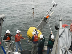
NOAA’s Center for Operational Oceanographic Products and Services (CO-OPS) is working with a prototype of a quick-response buoy that can be deployed when a HAZMAT spill occurs. The buoy collects real-time current speed and direction, wind speed direction and gusts, barometric pressure, and water and air temperature. The buoy can be deployed for up to 30 days.
In addition, scientists study nutrient, sediment, and the concentration of chemicals which travel in the water column, to understand how currents transport these materials locally and globally.
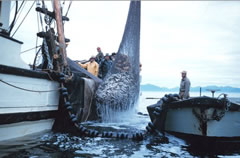
Finally, currents affect swimmers and fishers. Localized currents can be observed in the form of rip currents at the beach, or a piece of floating wood meandering in different patterns in a tidal bay or river. Swimming at the beach near rip currents can be very dangerous. Before going to the beach, learn how to recognize rip currents and strong shore currents, and pay attention to the warning signs. Recreational and commercial fishers pay close attention to the timing and strength of currents to maximize their chances of catching fish.
Currents Lessons
- Welcome
- Tidal Currents 1
- Tidal Currents 2
- Waves
- Longshore Currents
- Rip Currents
- Upwelling
- The Coriolis Effect
- Surface Ocean Currents
- Boundary Currents
- The Ekman Spiral
- Thermohaline Circulation
- The Global Conveyor Belt
- Effects of Climate Change
- Age of Exploration
- What is a "knot"?
- Shallow Water Drifter
- Deep Ocean Drifter
- Current Profiler
- Shore-based Current Meters
- How Currents Affect Our Lives?
- References
- Roadmap to Resources
- Subject Review