NOAA’s National Geodetic Survey (NGS) provides the framework for all positioning activities in the nation. The foundational elements of latitude, longitude, elevation, and shoreline information impact a wide range of important activities.
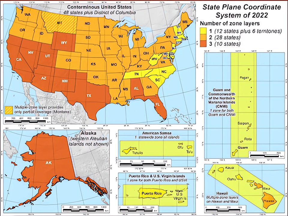
NGS Releases New State Plane Coordinate System
NOS Priorities: Increase U.S. Coastal Resilience; Accelerate Growth of the Ocean Enterprise and Blue Economy
Since its introduction in the 1930s, the NGS State Plane Coordinate System has been a popular product for surveying, engineering, and mapping. NGS is working on the third-generation system, the State Plane Coordinate System of 2022, or SPCS2022, as part of the National Spatial Reference System’s modernization. NGS released a preliminary, or alpha, version of SPCS2022 through several products, including an alpha SPCS2022 website; an alpha NGS Coordinate Conversion and Transformation Tool, or alpha NCAT; SPCS2022 online interactive maps; and updated SPC2022 policy and procedures. The alpha release allows software developers, state stakeholders, and other NGS partners and customers to provide feedback and influence SPCS2022 development toward its completion. This input will help prepare users for the future and ensure that SPCS2022 is an optimally designed part of the Modernized National Spatial Reference System.
Collection of maps display alpha versions of the State Plane Coordinate System of 2022 previewed on the new NGS alpha site. (Credit: NOAA)
Gravity Data Collection Over U.S., Including U.S. Pacific Islands, Completed
NOS Priorities: Increase U.S. Coastal Resilience; Accelerate Growth of the Ocean Enterprise and Blue Economy
The Gravity for the Redefinition of the American Vertical Datum (GRAV-D) team has completed three major milestones in FY 23. In April, with help from the NOAA Aircraft Operations Center’s NOAA WP-3D Orion aircraft, the GRAV-D team completed airborne gravity data collection of the Aleutian Islands. In June, with the NASA Langley Research Center Gulfstream IV jet, the team completed airborne gravity data collection in the Pacific Islands, including American Samoa and Hawaii. These remote regions are challenging to do because they require long-range aircraft, which are highly sought after and can be expensive. The monumental milestone for GRAV-D in 2023 is that the entire target area is now complete — all U.S. states and territories. This project has taken more than 16 years to finish. Because every dataset can be improved, the GRAV-D team will continue to re-fly lower-quality lines and regions that could benefit from more data collection.
Above is a map showing the gravity disturbance for the American Samoan region. Gravity disturbance is the difference between observed gravity and the normal gravity at the same location. Normal gravity can be calculated mathematically based on what the gravity field would be like if Earth was a uniformly dense ellipsoid. (Credit: NOAA)
Vertical Datum Tool Releases Extended Coverage of Puerto Rico and U.S. Virgin Islands
NOS Priorities: Increase U.S. Coastal Resilience; Accelerate Growth of the Ocean Enterprise and Blue Economy
NOAA’s online Vertical Transformation Datum software tool, known as VDatum, is an evolving tool that converts elevation data from various sources into a common reference system. VDatum has released an updated version with extended coverage over Puerto Rico and the U.S. Virgin Islands. The upgrade includes newly available Spatially Varying Uncertainty (SVU) estimates that allow users to estimate the accuracy of a vertically transformed dataset when trying to harmonize with other available spatial datasets, such as elevation models. With enhanced coverage and accuracy of VDatum from the shoreline into the Economic Exclusive Zone (200 nautical miles from the U.S. shorelines), users can now conduct transformations between reference systems to align and blend datasets together accurately. VDatum is able to transform between tidal, orthometric, and ellipsoidal reference systems, providing users a method for establishing a common reference system for mapping and other applications. The current and future developments in VDatum will also include the U.S. National Spatial Reference System (NSRS), a consistent coordinate system covering North America and the Pacific Ocean. This alignment with the NSRS will ensure continued support for mapping, charting, navigation, infrastructure development, resource evaluation surveys, and scientific applications.
Topography of the Sea Surface (TSS) model over Puerto Rico and U.S. Virgin Islands, providing the spatial variations between a mean sea-level surface and the geopotential surface (realized using a geoid model). TSS positive values indicate that the geopotential surface is further from the Earth’s center than the local mean sea-level surface. (Credit: NOAA)
Online Positioning User Service Projects (OPUS Projects) Upgraded to Include RTK, RTN Data
NOS Priorities: Increase U.S. Coastal Resilience; Accelerate Growth of the Ocean Enterprise and Blue Economy
NGS released its Online Positioning User Service Projects (OPUS) version 5, which provides management and processing tools for survey projects involving multiple sites and occupations. OPUS Projects 5 is the first version that allows users to include global navigation satellite systems vectors in their projects from real-time kinematic, real-time networks, or post-processed methods. To upload the vectors, users must use the GNSS Vector Exchange format, a standard file format for exchanging global navigation satellite system vectors derived from varying survey methods and hardware. Users can still use OPUS Projects 5 to efficiently establish geodetic control, align their data to the National Spatial Reference System, and submit the data to NGS for review and datasheet publication. In addition, several new features are available to assist with quality control analysis and exporting adjustment results to several common geospatial file formats.
OPUS projects supports the submission of GNSS survey data to NGS for publication on datasheets.
NGS Engages at International Surveyors Conference
NOS Priorities: Increase U.S. Coastal Resilience; Accelerate Growth of the Ocean Enterprise and Blue Economy
Nearly 30 NGS staff participated in the International Federation of Surveyors Virtual Working Week 2023 in Orlando, Florida. Held in the U.S. for the first time in 20 years, the event drew more than 1,000 geospatial professionals from around the world. NGS Director Juliana Blackwell delivered a keynote address, explaining how NOAA science, data, and tools support, protect, and enrich society. NGS supported two days of sessions, including a day on the National Spatial Reference System modernization and sessions for the Young Surveyors Network and the FIG Commission 5, which focuses on meeting the highest accuracy levels for positioning and measurement. These sessions raised surveyors’ awareness about cutting-edge geodetic technology and techniques and enhanced global cooperation to conform with the United Nations resolution for a Global Geodetic Reference Frame.
NGS staff attend the International Federation of Surveyors Working Week 2023 in Orlando, Florida. (Credit: NOAA)
 An official website of the United States government.