The Office of Coast Survey (OCS) provides navigation products and services that ensure safe and efficient maritime commerce on America’s ocean and coastal waters and in the Great Lakes.
NOAA Adds 3D to Surge and Tide Operational Forecast System
SUPPORTS NOS PRIORITY: NEW BLUE ECONOMY | COASTAL RESILIENCE
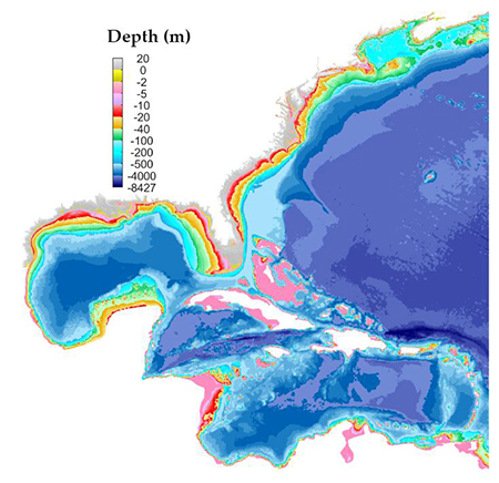
The Global 3D Surge and Tide Operational Forecast System coverage in the Atlantic domain illustrates water depths with different colors.
NOS’s Surge and Tide Operational Forecast System (STOFS) became operational in late 2022. This upgrade enhances the system’s performance, resolution, and coverage for the global depth-averaged (STOFS-2D-Global) model in the western Atlantic Ocean and in the Caribbean Sea, especially along the East and West coasts, Gulf of Mexico, Puerto Rico and U.S. Virgin Islands. This enhancement will improve water level forecast guidance, which can go out to 7.5 days at an updated rate of four times per day. As part of this upgrade, a new 3D (layered) modeling component (STOFS-3D-Atlantic) has been included into STOFS. This addition will support coastal flooding forecasting for the Atlantic basin (East Coast, Gulf of Mexico, and Puerto Rico). The system will use input from the National Water Model to include inland hydrology and extreme precipitation effects on coastal flooding, and will also provide surface current information to support marine navigation. NOS is working closely with the National Weather Service, providing technical and model output to support total water level implementation in the National Water Model. Future planned upgrades include improved spatial resolution and 3D coverage for the West Coast and Alaska.
NOAA Launches Prototype S-102 Navigation Data
SUPPORTS NOS PRIORITY: NEW BLUE ECONOMY | COASTAL RESILIENCE
In August 2022, NOAA released prototype high-resolution data for use by navigation systems in the ports of New York/New Jersey and Los Angeles/Long Beach. The prototype data leverages the International Hydrographic Organization’s S-102 Bathymetric Surface Product Specification. This specification is optimized for use in navigation systems and displays the bathymetric surface on a separate layer, providing a greater level of detail than a regular nautical chart, and using colors and shading to show depths in between contour lines. The S-102 standard is a critical component of the suite of Precision Marine Navigation products and services. In addition to creating product files, the data sets also maintain compliant discovery metadata that allows for machine-to-machine discovery and dissemination. Discovery metadata accompanies each data product and contains all relevant information, including boundaries and latest edition. The S-102 prototype data for these two ports was generated from OCS’s National Bathymetric Source (NBS), a continuously updated compilation of the best available bathymetry. As NBS continues to expand its operational area, NOAA will release additional S-102 prototype data for ports within that region.
S-102 data, visible in this screenshot from a navigation system, provides higher resolution and a greater level of detail than a traditional nautical chart.
Progress on U.S. Mapping Data and Data Licensing Policy
SUPPORTS NOS PRIORITY: NEW BLUE ECONOMY | CONSERVE, RESTORE, AND CONNECT
The third annual Progress Report on Unmapped U.S. Waters shows that 52% of U.S. waters remain unmapped as of January 2022 — a decrease of 1% since January 2021. Data on the depth, shape, and composition of the seafloor is critical to exploration, sustainable development, conservation, and managing coastal and offshore ocean resources. This progress report, compiled by NOS and released by the Interagency Working Group on Ocean and Coastal Mapping, shows that roughly 58,000 square nautical miles of new bathymetric data have been published at NOAA since the last analysis. The 2020 National Strategy for Mapping, Exploring, and Characterizing the United States Exclusive Economic Zone and the global Seabed 2030 initiative make comprehensive ocean mapping a priority for the coming decade. NOAA signed a memorandum of understanding in 2022 formalizing U.S. participation in Seabed 2030 and supporting NOAA's many mission areas reliant on bathymetry. In addition, OCS’s Data Licensing Policy is officially in place and aligns OCS with the NOAA Data Strategy and federal policies that require government data to be as free, open, and accessible as possible to spur and encourage exploration and innovation throughout the industry. This policy also requires that licensing be applied to external data contributions from the ocean mapping community.
NOAA works to collect and map data on the depth, shape, and composition of the seafloor in coastal, ocean, and Great Lakes waters in the United States.
NOAA Ships Spearhead Two Exceptional Survey Seasons in the Great Lakes and Western Pacific
NOS scientists conducted multiple hydrographic mapping missions during the 2022 field season aboard NOAA Ship Thomas Jefferson in the Great Lakes and NOAA Ship Rainier in Guam and the Northern Mariana Islands. The crew aboard Thomas Jefferson, along with OCS’s navigation response team and private sector partners, supported critical updates to marine navigation products and services and provided modern data to the scientific and benthic mapping communities. The data will provide the foundation for habitat maps and related products in cooperation with the National Centers for Coastal Ocean Sciences and other partners. The data also supports updated hydrodynamic models to improve the Great Lakes Operational Forecast System developed by OCS and Great Lakes Environmental Research Laboratory. This new high-quality NOAA data supports the management of Thunder Bay National Marine Sanctuary and the Wisconsin Shipwreck Coast National Marine Sanctuary. It is an example of the type of data that will be collected to support the proposed Lake Ontario National Marine Sanctuary. The project also included operational testing of an uncrewed surface vehicle. This was a major step toward full integration of crewed and uncrewed survey platforms into OCS operations, amplifying existing capabilities and increasing productivity, efficiency, and safety, especially in remote or extreme environments.
NOAA Ship Rainier’s RICHARD (Rainier Integrates Charting Hydrography And Reef Demographics) project combined three independent missions to one vessel, taking advantage of the ship transiting to the remote islands in the western Pacific. OCS collaborated with the National Geodetic Survey, Pacific Islands Fisheries Science Center and Coral Reef Conservation Program to collect high-resolution bathymetric data. NOAA will use this data and topo-bathymetric lidar data to create a seamless map linking the hilltops to underwater depths, which will be used to update nautical charting products, promote maritime safety, and support coral reef and coastal management. The team also collected reef assessment data — habitat characterization, sea surface level measurements, and water-column data — helping to inform multiple users across a variety of disciplines. In the end, this project acquired over 5,000 square nautical miles of high-resolution bathymetric data and conducted over 1,850 scuba dives. Many areas in the region had not been mapped in decades or had never been mapped to modern standards.
NOAA Ships Thomas Jefferson (top) and Rainier (bottom) during their 2022 field seasons. Thomas Jefferson is in the Great Lakes and Rainier is docked alongside Ford Island, in Pearl Harbor, Hawaii.
 An official website of the United States government.


Social