What is the custom dashboard feature of NOAA’s Coastal Inundation Dashboard?
Users can use this tool to view water levels in the path of a storm.
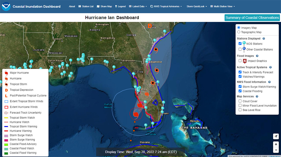
This custom dashboard, generated in September, 2022, shows Hurricane Ian approaching Florida’s Gulf Coast. The custom dashboard is a feature of NOAA’s Coastal Inundation Dashboard.
NOAA’s Coastal Inundation Dashboard provides near real-time water level information at NOS water level stations through the lens of coastal flooding. During a hurricane or tropical storm, a storm-specific dashboard is created to highlight how coastal water levels are responding to the tropical cyclone.
When NOAA’s National Weather Service (NWS) issues a tropical storm watch or warning for the U.S. or its territories, a custom dashboard is created with a unique storm URL. This free online tool displays near real-time water level conditions for areas impacted by a tropical cyclone, highlighting stations that may be experiencing coastal flooding.
Through the custom dashboard, users can also view the latest tropical cyclone forecast track and intensity, allowing them to quickly identify water level stations in the path of the storm. Here are some of the available features:
Real-time water level and meteorological observations
GIS map integrating storm track and intensity, active coastal flood and storm surge watches and warnings (issued by NWS), overlaid upon NOS water level station locations
Summary of present conditions across the affected region
Predicted high tides at NOS water level stations along the coast
Latest NOAA National Hurricane Center Public Advisory Text
Coastal decision-makers, emergency managers, port operators and residents can use the custom dashboard to more easily monitor water levels and make informed decisions before, during, and after a storm.
The Coastal Inundation Dashboard is maintained by the NOS Center for Operational Oceanographic Products and Services (CO-OPS), NOAA’s tides and currents experts. The Dashboard brings together key NOS products and data from over 200 long-term water level stations into one free, online tool that can help coastal communities monitor and prepare for all types of coastal flooding, from high tide flooding to storm surge. The tool provides real-time water level information, 48-hour forecasts of water levels, and historic flooding information — all in one place.
 An official website of the United States government.
Social