NOAA and Partners Dedicate Jacksonville PORTS®
Real-time information now available to mariners in the Port of Jacksonville.

Cruising Through
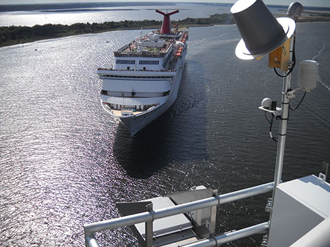
The air gap sensor installed on the Dames Point Bridge in Jacksonville, Florida, ensured that Carnival Cruise Lines could continue serving the Port of Jacksonville while the bridge was undergoing repairs. The cruise industry generates over $67 million in annual economic impact for Northeast Florida. (Image credit: Steve O’Malley, Ocean Tech Services, LLC)
PORTS® facilitates safe and efficient movement through U.S. seaports, helping to ensure our nation’s economic health and prosperity.
On July 23, NOAA and its local partner, the Jacksonville Marine Transportation Exchange, dedicated the newest Physical Oceanographic Real-Time System, or PORTS®. The new Jacksonville PORTS®, the second largest established in the national system, includes 46 operational sensors that cover water level, meteorological, visibility, salinity, air gap (under bridge clearance), and currents.
Jacksonville PORTS® was designed to provide mariners with data for safer navigation given the dynamic conditions and changes in water levels and currents of the St. Johns River, an area that vessels must transit to reach the Port of Jacksonville and other locations along this waterway.
What is PORTS®?
PORTS® is a local observing system, determined by user needs in the region, that measures and disseminates oceanographic and meteorological observations and predictions. Users can access PORTS® data from a desktop computer, mobile device, or phone voice system. There are currently 23 PORTS® located around the U.S. providing critical data for safe navigation of both commercial and recreational users.
In addition to supporting safe navigation, the real-time information provided by PORTS® helps port managers balance environmental and economic priorities as maritime activity within a port increases. This data can help mariners maximize their cargo load while minimizing risks associated with groundings and collisions. Other benefits from PORTS® includes an improved response to distress calls, more effective response to hazardous spills, and better information for coastal management.
As our exports continue to grow, PORTS® facilitates their safe and efficient movement through U.S. seaports, helping to ensure our nation’s economic health and prosperity. PORTS® is one component of the greater coastal intelligence picture, helping to provide actionable information today for stronger, more resilient communities of tomorrow.
This project was administered by the Jacksonville Marine Transportation Exchange with station installation, operation, and maintenance services provided by Woods Hole Group, Inc. NOAA provided technical guidance during the project and will continue to provide ongoing quality control and dissemination of the data to support safe navigation in this community.