Low or depleted oxygen in a water body often leads to 'dead zones '— regions where life cannot be sustained.
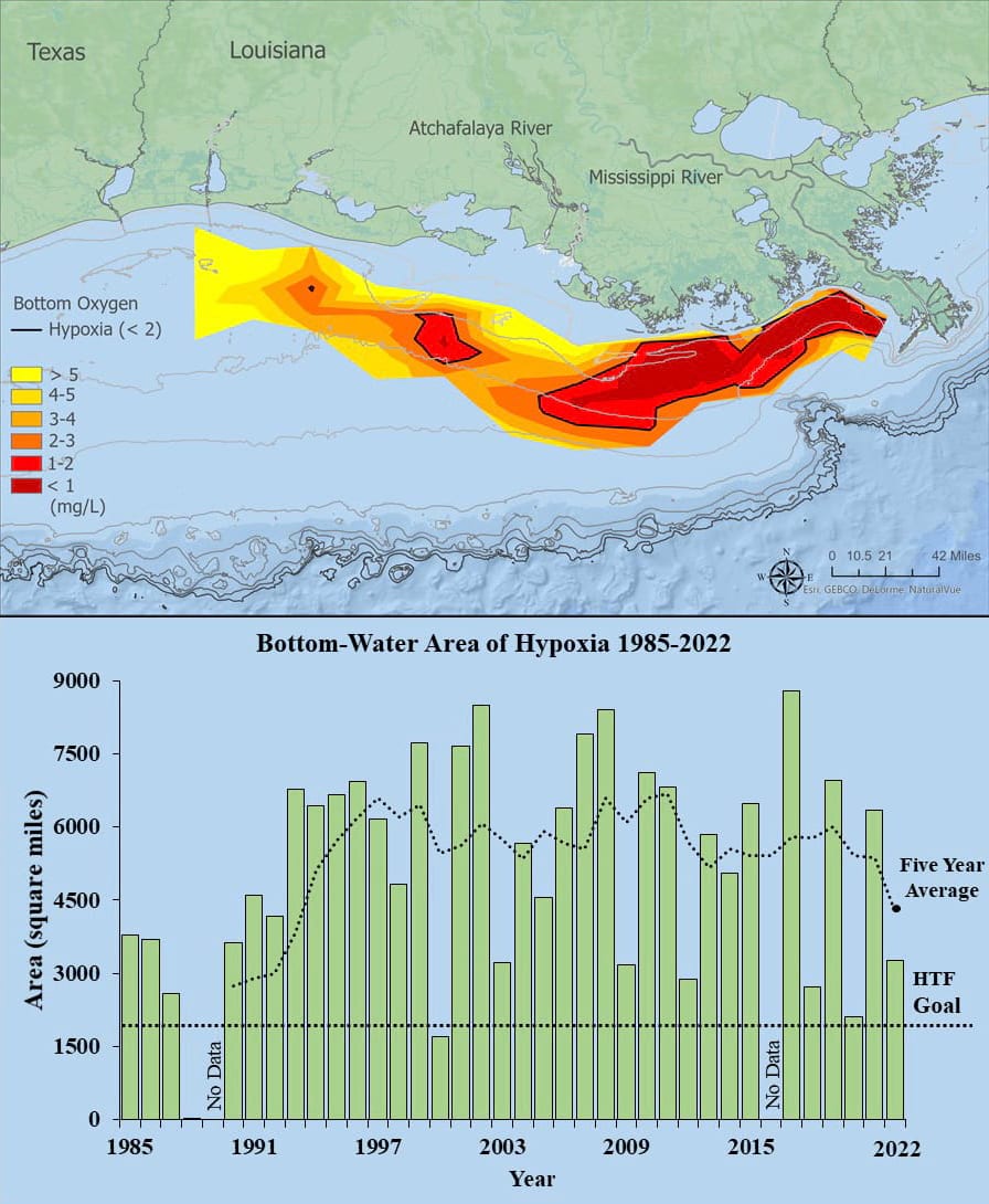
At 8,482 square kilometers (3,275 square miles), the 2022 hypoxic zone in the Gulf of Mexico is the 8th smallest ever measured in the 36-year record, measured from July 25 to August 1, 2022. Red area denotes 2 milligrams per liter of oxygen or lower, the level which is considered hypoxic, at the bottom of the seafloor. (Bottom panel) Long-term measured size of the hypoxic zone (green bars) measured during the ship surveys since 1985, including the target goal established by the Mississippi River/Gulf of Mexico Watershed Nutrient Task Force and the 5-year average measured size (black dashed lines). Graphic credit: Louisiana Universities Marine Consortium
In ocean and freshwater environments, the term "hypoxia" refers to low or depleted oxygen in a water body. Hypoxia is often associated with the overgrowth of certain species of algae, which can lead to oxygen depletion when they die, sink to the bottom, and decompose.
Hypoxia Causes 'Dead Zones'
In some cases, vast stretches of open water become hypoxic. Unable to sustain life, these areas, called dead zones, may cause die-offs of fish, shellfish, corals, and aquatic plants. Since 1985, NOAA-sponsored research has monitored the largest dead zone in the United States, which forms every spring in the northern Gulf of Mexico. In 2019, it grew to cover more than6,900 square miles of the sea floor.
The amount of oxygen in any water body varies naturally, both seasonally and over time. This occurs due to a balance between oxygen input from the atmosphere and certain biological and chemical processes, some of which produce oxygen while others consume it.
Stratification in the water column, which occurs when less dense freshwater from an estuary mixes with heavier seawater, is one natural cause of hypoxia. Limited vertical mixing between the water "layers" restricts the supply of oxygen from surface waters to more saline bottom waters, leading to hypoxic conditions in bottom habitats.
Hypoxia occurs most often, however, as a consequence of human-induced factors, especially nutrient pollution (also known as eutrophication). The causes of nutrient pollution, specifically of nitrogen and phosphorus nutrients, include agricultural runoff, fossil-fuel burning, and wastewater treatment effluent.
NOAA studies and funds research on the causes and impacts of hypoxia. NOAA also collaborates with local, state, and federal agencies, regional task forces, universities, conservation organizations, and industry partners to develop management strategies to reduce nutrient inputs into coastal waters.
Much of NOAA's hypoxia work is managed through NCCOS, which studies and monitors the effects of hypoxia and other sources of pollution nationwide. NCCOS has funded the development of hypoxia forecasts in the Gulf of Mexico since 1990 and in the Chesapeake Bay since 2005.
In the Gulf of Mexico, this research helped the Mississippi River/Gulf of Mexico Watershed Nutrient Task Force set goals and prioritize actions to reduce the size of the annual Gulf of Mexico Dead Zone. In Chesapeake Bay, the research is providing important information to interagency management bodies like the Chesapeake Bay Program.
The Gulf of Mexico Hypoxia Watch evolved as a cooperative project among NOAA's National Marine Fisheries Service - NMFS, NCEI at Stennis, and the CoastWatch - Caribbean/Gulf of Mexico - Regional Node. Hypoxia Watch provides near-real-time data and map products using shipboard measurements of bottom-dissolved oxygen. These products help scientists prep for the yearly monitoring cruise by informing them of the potential extent of hypoxia in the Gulf of Mexico.
In addition, NOAA's Ecological Forecasting Roadmap initiative is developing a national framework for hypoxia and other ecological forecasts (e.g., harmful algal blooms, pathogens) so that their benefits to the public can be sustained and improved over time.
The Harmful Algal Bloom and Hypoxia Research and Control Act of 1998 (HABHRCA 1998, reauthorized in 2004, 2014, and 2019, Public Law 113-124) reaffirmed and expanded NOAA's mandate to advance scientific understanding of hypoxia, and support scientists' ability to detect, monitor, predict, and mitigate occurrences of hypoxia and harmful algal blooms.
 An official website of the United States government.
Social